Jerusalem's Old City
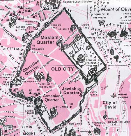
The Old City is divided into four neighborhoods, which are named according to the ethnic affiliation of most of the people who live in them. These quarters form a rectangular grid, but they are not equal in size. The dividing lines are the street that runs from Damascus Gate in the north, to the Zion Gate in the south — dividing the city into east and west — and the street leading from the Jaffa Gate in the west, to Lion's gate in the east — which bifurcates the city north and south. Entering through the Jaffa Gate and travelling to David Street places the Christian Quarter on the left. On the right, as you continue down David Street, you'll enter the Armenian Quarter. To the left when you cross over Ha-Yehudim Street (Jews Street) is the Muslim Quarter, and to the right is the Jewish Quarter.
Click here to view this on a modern street map.
Click here for its hyperlink in Google maps.
Click here for further details about this overview of the city.
Now for some history
This Wikipedia link to the Old City of Jerusalem shows it to be just 0.9 square kilometers, a walled area having a 4 km circumference. At the time of Josephus when the walls were destroyed, it is recorded as 6½km. These current walls were built in 1538.
The original City of David, also known as Mount Zion, shows walls further to the south. Click here for an artist's model of this "stronghold of Zion", the City of Jebus in 1000 BC prior to King David's reign, after which it became known as this "City of David". Where David brought the Ark ("chest") of the Covenant ("original scrolls"), and placed it in its own tabernacle ("tent").
Click the appropriate number for five sketches of Jerusalem:
- One at the time of King David
- Two its extension in the days of Solomon, including the Temple, Palace, Mishneh-section, up to its ransacking by Nebuchadnezzar.
- Three at the time Nehemiah rebuilt its walls in 404 BC. Its border and extension towards the west, as mentioned by Nehemiah, included the Broad Wall that had been built by King Hezekiah. Click here to see that location today on a Google map, just inside the Jewish Quarter.
- Four at the time of Christ showing Pilate's praetorium built by Herod the Great about 20 BC, also its "second" wall
- Five at the time of Josephus and its "third" wall started by Herod Agrippa about 44 AD.
Click here for a map (estimate) of where the gates had been in first century Jerusalem.
As well as building a palace on the western side, Herod extensively modified the Temple Courtyard circa 488 metres x 281 metres with the Temple Building forming a square of about 200 metres (one furlong) on each side. Click here for an image and here for further details (estimate). The temple courtyard consisted of a broad "outer" court for non-Jews with dire warnings for any Gentile who dared to step over its boundaries into the narrow "inner" courtyard area. Click here for another image of the area looking north-east.
Herod's palace was destroyed in the Jewish War of 66 AD, that followed the failures of first the local Roman Governor Gessius Florus and secondly the Syrian Governor Cestius Gallus, who, somewhat in fulfilment of Jesus's warning in Luke 21:20, surrounded Jerusalem in 66 AD but was unable to quell the rebellion. In the chaos of a murderous civil war that erupted between Jewish factions, many Christians subsequently fled to Pella (in modern day Jordan). Surrounding Jerusalem a second time in 70 AD but allowing no escape, only crucifixion and enslavement, Roman General Titus leveled first the northern, then the western and eastern walls of Jerusalem, burning and demolishing the Temple and nearly all the homes of the city, leaving just three towers in the west and the southern wall for his troops.
It was to be 200 - 300 years later before a new wall was constructed around the city. Significant additional construction has been attributed to the time of the empress Aelia Euodia, who in 425 AD granted the Jews permission to resettle in the city, to pray by the ruins of the Temple.
In 637 AD the city was taken by the Arab Muslims, with the Dome of the Rock constructed in 691 AD. Following a number of earthquakes, including a severe one in 1033 AD, a southern wall was rebuilt northwards in the current southern wall's position, now excluding the old City of David.
As mentioned earlier, these current walls were built in 1538 by Suleiman the "Magnificent", the Turkish Ottoman ruler.
While Jews outnumber Arabs in Jerusalem proper, inside the Old City Arabs outnumber Jews by nearly 10 to 1, there being about 37000 Arabs and only about 3800 Jews. Jews have been outnumbered here in fact for most of the past 2000 years, ever since Jerusalem was destroyed by the Romans in 70 AD. But in the late 19th Century, Zionism — a desire to establish a Jewish homeland in Israel (centred around Mount Zion at Jerusalem) — steadily grew.
Extract from tj-jfe.mbarsinai.com
| At the end of the nineteenth and the beginning of the twentieth century, the Jewish community was the majority in the Old City. With the migration to the new city, the number of Jews in the Old City declined. The trend towards leaving the Old City was mainly due to difficult living conditions, high density and a poor sanitation system. Those who could, moved to the new area and only the lower class remained in the Jewish Quarter. |
Below is the demographic data of the Jewish settlement in Jerusalem between the First Aliyah and the establishment of the State of Israel
| Year | 1880 | 1900 | 1910 | 1931 | 1948 | 2020
| | Jews in the Old City | 19,000 | 15,000 | 16,000 | 5,500 | 2,000 | 3,800
|
| Jews in the New City | 2,000 | 16,000 | 29,000 | 48,000 | 98,000 | 600,000 approx.
|
| Total number of Jews in Jerusalem | 21,000 | 31,000 | 45,000 | 53,500 | 100,000 | 603,800 approx. |
In 2020, about 300,000 Palestinian Arabs live in Jerusalem (new city) and about 37,000 live in Jerusalem (old city).
The Four Quarters
Click each image below to see better detail.
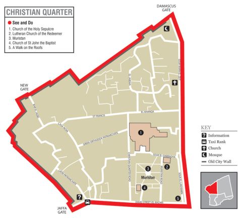
Christian quarter
The northwestern sector of the Old City. The Christian quarter's population is estimated at about 4,000 residents.
This quarter includes the sites that, since 330 AD, commemorate the place where Jesus was buried and resurrected, and a few metres to the left of this tomb — just outside the "second" city wall at the time of Christ — a small hill commemorating the place where he was crucified and died. Thus, as well as the final stations of the cross (Via Dolorosa), this quarter includes
- the Church of the Holy Sepulchre first commissioned in 326 (shared by multiple traditions including Greek Orthodox and Roman Catholic and Armenian, Syriac, Coptic, and Ethiopian Orthodox - with the wider complex serving as the Greek Patriarch's headquarters)
- the Church of Saint John the Baptist (Greek Orthodox) first built in the 4th-6th century
- the Church of Our Lady of the Annunciation (Melkite Greek Catholic) built in 1848
- Christ Church (Anglican) consecrated in 1849
- the Holy Name of Jesus Co-Cathedral (Roman Catholic) completed in 1872
- Holy Trinity Cathedral (Russian Orthodox) also completed in 1872
- Church of the Redeemer (Lutheran) dedicated in 1898
also the Muristan (the "Hospital"). Monks from the Benedictine order tended the sick and wounded warriors following the Crusades in 1099. This group evolved into a new local group in 1113 AD, naming their order after John the Baptist, and were called the "Knights Hospitallers of St. John", or the Hospitallers.
In the south west is Jaffa Gate, the main entrance to the city from the west.
Since the mid-nineteenth century, the Garden Tomb that is just north of the Damascus Gate and the old city walls — also having a skull-like hill (Golgotha) close by — has many agreeing that this was in actuality where Jesus was crucified, died, was buried and was resurrected. Click here for photos and a map.
|
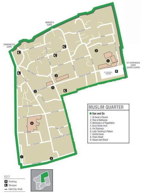
Muslim quarter
The northeastern sector of the Old City. Its population is estimated at about 30,000 or more than 70% of the population.
The Via Dolorosa starts in this quarter. As the largest and most populous, it extends from the Lions' Gate in the east, along the northern wall of the Temple Mount in the southeast, to the Western Wall route and northwards along the shop-lined Souk Khan El-Zeit (Beit Habad Street Market) to the Damascus Gate (also known as Sha'ar Shkhem / Shechem Gate or Nablus Gate) in the northwest.
Today, there are also many Israeli settler homes. It's a warren of alleyways (covered or exposed) and, as you move away from the tourist tack of the Via Dolorosa and immediate surrounds, you find butchers, clothing, bakers, sweet and spice stalls etc. Damascus and the less used St Stephen's (also known as Lion's) gates are the main access/egress points for this section. Damascus gate epitomises the melee of the quarter, with thousands of people leaving and entering the city throughout the day.
|
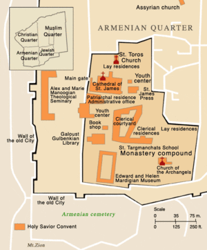
Armenian quarter
Its population is estimated at about 2,400 residents.
One of the most private parts of the Old City, the Armenian quarter in the south west is dominated by high walls with little opportunity to see beyond. The Cathedral of St James is a case in point — only the inner front entrance and inner courtyard are accessible to the general public.
|
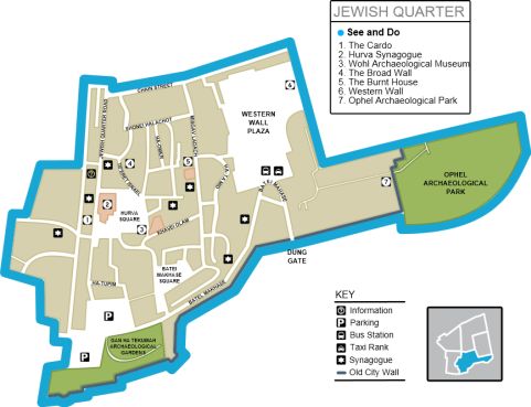
Jewish quarter
prior to 1967 known as the Moroccan Quarter. As the southeastern sector of the Old City it is situated just north of the City of David.
Its population is currently estimated at about 3,000 residents plus an additional 1,500 yeshiva ("academic") students. The numbers have reduced greatly since the years 1880-1910 when it was quite overcrowded as Jews purchased houses, owning about 20% of the quarter. At the start of 1948 most Jewish residents had moved west into the new city, leaving just 2,000 who then left "en masse" with that takeover by Jordan.
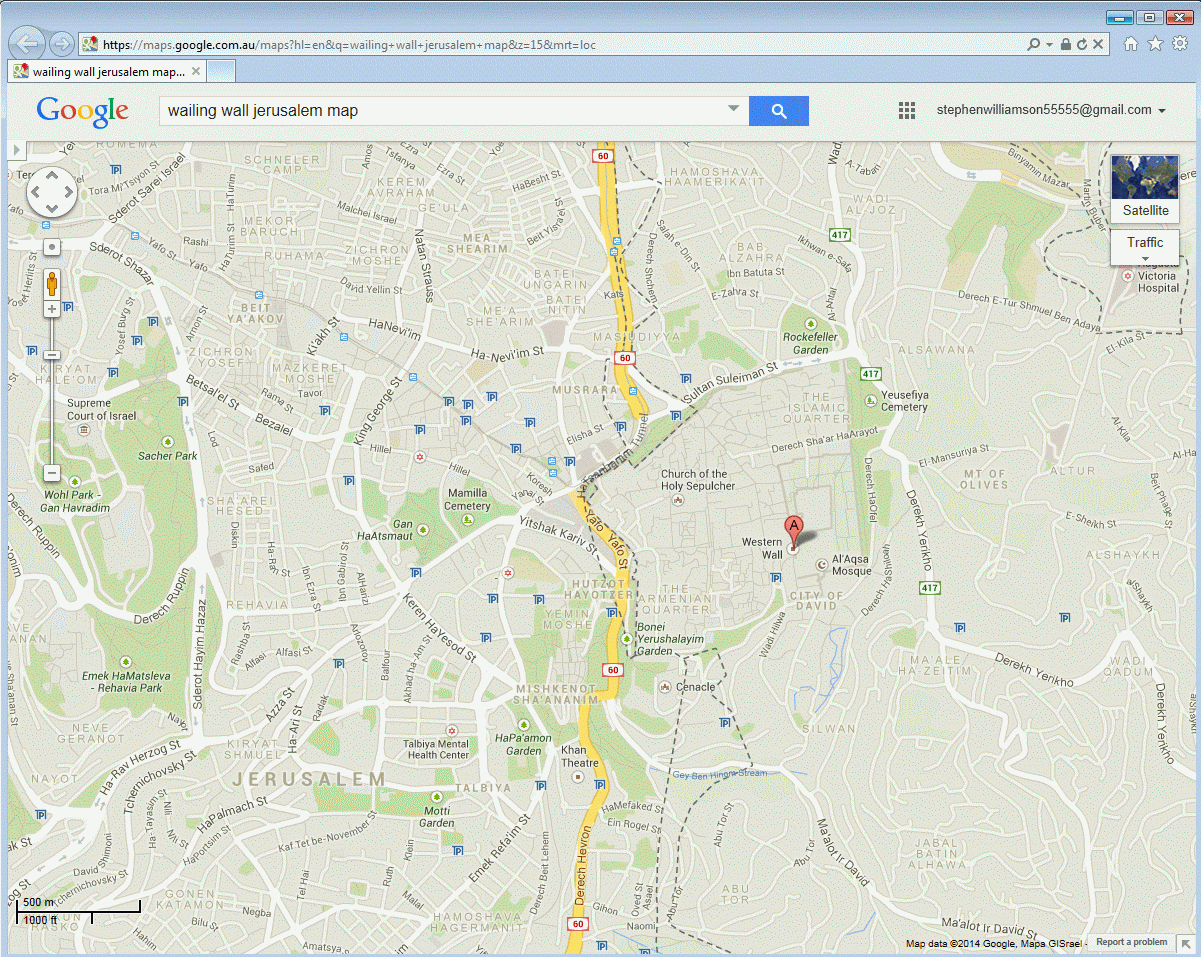
It stretches from the Zion Gate (midway along the southern wall of the Old City that lines the Armenian Quarter), northwards along Habad Street that runs beside the Armenian Quarter on the west, up to ha-Shalshelet / Chain Street in the north, and extends to the Western Wall Ha-Kotel Ha-Ma'aravi — about 57 metres long, and known as the Wailing Wall to outsiders.
Click here for a photo, facing east. Click here for a live webcam, showing the Dome of the Rock in the background to its left, and the Al-Aqsa Mosque to its right.
After 1193, and prior to 1967, this quarter was known as the Moroccan Quarter when Saladin's son opened it up to Moroccan immigrants who were taking up residence there. It thus confined the Jews to a narrow neighborhood, Hayya al-Sharif, that allowed them access to the Wall just along King David Street.
During the 1800s many Jews returned to the Old City and to this quarter. But it was taken over holus-bolus by Jordan in May 1948, thus cutting off all access. It was taken back by Israel in June 1967. After 1967, about 650 Palestinian residents received compensation when they had their houses razed in order to build the Western Wall Plaza.
Today Jordan is the custodian for just the Temple Mount and the Al-Aqsa Mosque, the focal point for Palestinians who are seeking for their capital to become East Jerusalem. Click here for some recent history.
Click here for an aerial view of the City of David, an area just south of this quarter. It shows the Gihon Spring, source of the city's water supply, located 67m below the top of the ridge on which the city was first built.
|
Below is a Google Map snapshot of the old city.
Click here to zoom in or zoom out.
Click here to see maps of Israel, and the surrounding countries.
**End of Page


