Details

The islands we now call Vanuatu were home to Melanesians for over 2,500 years. Then, in the 15th century, European explorers and missionaries began arriving and the islands changed forever.
Captain James Cook sailed through the chain in 1774, chartering and naming many of the islands. He collectively named them the New Hebrides, after the islands off the west coast of Scotland.
Known as the New Hebrides, they were administered jointly by Britain and France for 73 years. National pride finally took hold, forcing independence in 1980, along with its new name (Vanuatu) and a new constitution.
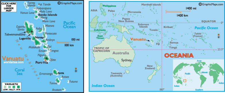
Located directly west of Fiji, Vanuatu is famed for gorgeous islands, active volcanoes and a very-intact Melanesian culture, especially on Tanna.
Vanuatu includes 13 larger islands and about 70 smaller ones. Most are mountainous (volcanic in origin) (some active), and covered in lush rain forests. Many are protected by coral reefs.
The islands are subject to devastating cyclones (hurricanes). The most destructive one ever (in 1987) damaged or ruined most of the local dwellings.
The local economy still revolves around agriculture and fishing, but tourism is a fast-growing industry and liberal tax laws have made Vanuatu a popular offshore financial center.
While most of the outer islands maintain their traditional Melanesian lifestyle, the impressive city of Port-Vila is crammed with colonial buildings, expats, duty-free shops, casinos, open-air markets, upscale restaurants and tourists.
For additional info about Vanuatu, go here.
Facts and Figures
 Official Name Republic of Vanuatu Official Name Republic of Vanuatu
Population 188,700
Capital City Port-Vila (35,300)
Flag
here
Languages English, French, Pidgin, and numerous local dialects
Official Currency Vatu
Currency Converter
here
Religions Presbyterian, Anglican, others
Land Area 12,190 sq km (4,707 sq miles)
Latitude/Longitude 17? 74S, 168? 31E
Highest Point Mount Tabwemanasana stands at 6,165 ft. (1,879 m)
 Time and Date in Port Vila Time and Date in Port Vila
Contact Us | Privacy Statement
Copyrighted by Graphic Maps
All rights reserved!
All maps, graphics and original descriptions created by Graphic Maps, a d/b/a of the Woolwine-Moen Group, unless otherwise noted and/or directly linked to the source, and use of same for any application whatsoever (with the exception of outline maps) requires written permission.
We make no copyright claim on any statistical data on this page, nor on any non-original graphics, and/or pictures not produced by us. Certain statistical data is gathered from the CIA World Factbook, as well as numerous public domain reference materials.
Every effort is made to be as accurate as possible when disseminating information on any worldwide destination. We are not responsible for unintentional data entry errors or omissions. If you would like to submit an addition, change or correction, or suggest a new link, please forward it to our map department and we will give it our immediate attention.


|
|

|
Maps
Vanuatu Large Color Map here
Vanuatu Map CIA version here
Vanuatu Outline Map here
Vanuatu Maps at UT here
Oceania Maps here
Suggested Links
Vanuatu (Complete) information on the (GDP) overall economy, imports and exports, resources, government, population, military, transportation, and more here
Vanuatu Photos here
Climate Vanuatu's weather is warm and humid, but winter temperatures do moderate some because of the prevailing southeasterly trade winds. As a general rule, the southern islands are cooler and drier than those of the north.
December through March is the cyclone season, with hot and rainy conditions throughout the islands.
Note that Vanuatu's seasons are just the opposite of those in the Northern Hemisphere, as Spring is (Sept-Nov), Summer is (Dec-Feb), Fall is (Mar-May) and Winter is (Jun-Aug).

Africa | Antarctica | Asia | Australia/Oceania
Europe | Islands/Oceans | Middle East
North America | South America
World Atlas

Posters and Prints
of Oceania
|
|
|
Oceania

Countries
Australia
Fiji
Kiribati
Marshall Islands
Micronesia
Nauru
New Zealand
Palau
Papua New Guinea
Samoa
Solomon Islands
Tonga
Tuvalu
Vanuatu
Dependencies
American Samoa
Cook Islands
French Polynesia
? Marquesas Is.
? Society Is.
? Bora Bora
? Moorea
? Tahiti
Guam
New Caledonia
Niue
Norfolk Island
Northern Marianas
? Saipan
Pitcairn Islands
Tokelau
Wallis and Futuna