Israel - Deep inside the plucky country
Go to Newspaper Article in 2008
Psalm 122:6-9
| ||||
| ||||
Click here for news in Oct 2025
Click here for Jerusalem's 3000 year history and a modern map focusing on the Western (Wailing) Wall. It includes links and maps to the four quarters of the old city, and a link to Google Maps for "zoom" in and out purposes.
Click here for a map of the Exodus about 1505 - 1465 BC.
Click here for this scripture based timeline.
Click here for a map of the twelve tribes at the time of Joshua about 1459 BC (from www.bible-history.com/geography/maps).
Click here for a map at the time of Samuel (and Saul) about 1015 BC, focusing on Kiriath-jearim (modern day Kiryat Ye'arim) about 10kms west of Jebus (modern day Jerusalem).
It became the location for the ark (chest) of the covenant after it had been removed from the tabernacle (tent) at Shiloh and then (briefly) captured by the Philistines. After David became king, he placed the ark inside its own tabernacle in Jerusalem, shortly after 968BC, where it remained until his son Solomon's dedication of the temple, about 912BC.
The original tabernacle, click here for an image, was moved from Shiloh and was later found at Nob, near Jebus (Jerusalem), with the priests who allowed David and his men access to the holy bread offering. After the priests were massacred for their "treasonable" communication with David, the tabernacle was located in Gibeon, during the 40 years of David's reign. Finally, at the time of Solomon's dedication of the temple, the tabernacle was stored inside the temple by the priests. No further mention is made of it.
Click here for a map about 800 BC.
Click here for a map at the time of the Romans in the 1st century AD.
Prior to World War One, oversight of most of Palestine came via the Ottoman Turkish province of Damascus (capital city of modern day Syria). Within Palestine, in the area referred to as ancient Judaea and Samaria there were two major administrative districts:
1. Nablus ancient Shechem in the north, a place where Jesus met the woman at the well, a place where Abraham purchased a plot that the "sons of Jacob" ?? were said to be buried in according to Stephen in Acts 7:16, the place of Joseph's tomb according to Joshua 24:32 — and from 1872 answerable to the Ottoman province of Beirut.
2. Salem (Jerusalem) in the south — the place of David's tomb and from 1841 directly answerable to the Ottoman administration in Constantinople (Istanbul).
In 1831, war between Egypt with initial French support and Ottoman Turkey resulted in the temporary takeover of Syria and Palestine by the Egyptian Governor (Pasha). Following a second war in 1839-1840 and further Ottoman defeat, British and Austrian naval forces sent in troops to maintain the peace and Egypt withdrew, click here for further details. Following Russia's withdrawal from Ottoman territory in 1856 after the Crimean War and in order to maintain its overland trade route to India, Britain established an increased presence in northern Egypt, building the Alexandria-Cairo railway in 1856. In 1875, it purchased cash-strapped Egypt shares in the Suez Canal (opened 1869). Click here for some further background.
When the Ottoman Empire joined the war on Germany-Austria's side, England deposed their Egyptian Khedive (Turco-Persian word for Lord) Abbas II, who had been earlier in Constantinople, and appointed his uncle Hussein Kamel as Sultan of Egypt (an Arabic word), with Egypt becoming a British protectorate under martial law for the course of the war. Upon Kamel's death in 1917, he was succeeded by his brother Fuad. Following Britain's granting Egypt full independence in February 1922, Fuad adopted the title of King (Malik in Arabic).
King Fuad authorized the Cairo Quran (of 1924) (also known as the Azhar Quran) which, following its major acceptance in Saudi Arabia, became the definitive Arabic translation worldwide.
Back to 1916 Click here for a planned map of Palestine as the West prepared for the Ottoman Empire's defeat. It established a joint oversight of Palestine and Syria and eastern Turkey by England, France and Russia.
However
1. the UK War Cabinet Meeting (Balfour Declaration) on 31st October 1917 that approved partnering with the Zionist Federation in the war with Germany and Turkey, and followed seven days later with the October Bolshevik Revolution ("Workers of the World, Unite") that opposed any Jewish "Nationalist" faction, and sued for peace with Germany.
2. Moscow newspapers on 23 November 1917 published that 1916 layout of planned Middle East states encompassing diverse groups that often had historical grievances against each other. It was followed by Manchester England doing the same on 26 November, causing considerable embarrassment to the British High Commissioner in Egypt, Henry McMahon, who resigned in protest.
3. the initial "Welcoming the Jews Back Home" in Paris by Emir Faisal on behalf of all the Arabs at the Peace Conference in 1919, but he rejected a "Jewish National Homeland" as King of United Syria in March 1920.
It led to the San Remo conference resolution adopted on 25 April 1920. Britain received the Mandate for Palestine, with the huge task of building the Jews their national homeland. It provided nothing be done that prejudiced the civil and religious rights of existing non-Jewish communities in Palestine, nor the rights and political status enjoyed by Jews in any other country. And throughout this tiny country, investment poured in, swamps were drained, the desert blossomed like the rose. Massively attractive, bringing an enormous increase in Jewish immigration to Palestine. And continuing unrest, that grew with the discovery of more, and more oil deposits (and its resulting material stress) throughout the Middle East. Finally culminating in Hitler's "final solution" as he partnered with the Grand Mufti of Jerusalem. Click here for further details on this period.
Below is a demographic history between 1850 to 1948.
- According to Wikipedia, Palestine in 1850 had about 350,000 inhabitants, roughly 85% were Muslims, 11% were Christians and just 14,000 (4%) were Jews.
- In 1914 Palestine had a population of 797,000 with roughly 657,000 Muslim Arabs, 81,000 Christian Arabs, and now 59,000 Jews.
- After the fall of Jerusalem to the British in 1917, by 1919 the total population in Palestine had fallen to just over 700,000.
80% were Muslims (560,000), 77,000 were Christian Arabs, and now 85,000 were Jews. - In 1946 the population became 1,947,000 during the British Mandate, with the Arab population increasing to 1,269,000, a doubling of their numbers in 1914.
The Jewish population had become 678,000, a ten-fold increase over their numbers in 1914.
Click here for yearly Jewish immigration from 1920 to 1945, totalling 367,000.
Click here for the UN vote in November 1947 that established a Jewish state and Arab state side by side. It required two-thirds of all voting members to be in favour in order to succeed. Details listed below.
- 33 nations voted in favour (72% of voting members)
Australia, Belgium, Bolivia, Brazil, Byelorussian S.S.R., Canada, Costa Rica, Czechoslovakia, Denmark, Dominican Republic, Ecuador, France, Guatemala, Haiti, Iceland, Liberia, Luxemburg, Netherlands, New Zealand, Nicaragua, Norway, Panama, Paraguay, Peru, Philippines, Poland, Sweden, Ukrainian S.S.R., Union of South Africa, U.S.A., U.S.S.R., Uruguay, VenezuelaWith the German invasion of Russia in 1941, Joseph Stalin reversed his long-standing opposition to Zionism and tried to mobilize worldwide Jewish support for the Soviet war effort. From late 1944, Stalin adopted an openly pro-Zionist foreign policy apparently in the belief that the new country would be socialist and would speed the decline of British influence in the Middle East.
- 13 nations voted against (28% of voting members)
Afghanistan, Cuba, Egypt, Greece, India, Iran, Iraq, Lebanon, Pakistan, Saudi Arabia, Syria, Turkey, Yemen - 10 nations abstained
Argentina, Chile, China, Colombia, El Salvador, Ethiopia, Honduras, Mexico, United Kingdom, Yugoslavia - 1 nation, Thailand, was absent
The historic vote was followed with unparalleled excitement on radio by Jews around the world, while news of the positive outcome brought thousands onto the streets across the future state to dance and celebrate the great moment.
But it was emphatically rejected by the local Arab population and the Arab States who openly declared their intention of preventing the creation of the Jewish State by all means. A wave of violent attacks was launched against the Jewish population and when Israel declared its independence on May 14, 1948, five Arab armies invaded the new state the same night, seeking its annihilation. Israel prevailed however in what came to be known as its
Of the estimated 950,000 Arabs that lived in the territory that became Israel, over 80% fled or were expelled. The other 16%, some 156,000, remained and became full citizens, while their brethren became "perpetual refugees" in the political struggle against Israel. Some 800,000 Jews were expelled from Arab countries, finding refuge and a new home in Israel.
In 1949 Egypt controlled the Gaza Strip, while Jordan annexed the West Bank, issuing Jordanian passports until 1988 to all Palestinian Arabs requesting one. In Cairo an "All-Palestine" passport was made available from 1949 to 1959 following which President Nasser renamed Egypt the "United Arab Republic". The UAR lasted until Nasser's death in 1970, following which Egypt renamed itself the "Arab Republic of Egypt", in 1971.
In June 1967, following the
Following a peace treaty in 1979 the Sinai was returned to Egypt 1980-1982. In 1995, two years after the Oslo Accords of 1993, Palestinian Authority passports were issued to the public in Gaza and Jericho, using personal ID numbers issued by the Israeli Civil Administration. In September 2005 Israel withdrew the last of its troops from the Gaza Strip.
Below is a table published in Wikipedia in 2018 of Palestinian refugee camps, with funding of $US1.2 billion yearly coming from voluntary contributions to the UNRWA. It is estimated 50% of refugees are under 25.
| 1950 | 1960 | 1970 | 1980 | 1990 | 2000 | 2004 | 2009 | 2018 | |
|---|---|---|---|---|---|---|---|---|---|
| Jordan | 506,200 | 613,743 | 506,038 | 716,372 | 929,097 | 1,570,192 | 1,758,274 | 1,951,603 | 2,242,579 |
| Lebanon | 127,600 | 136,561 | 175,958 | 226,554 | 302,049 | 376,472 | 396,890 | 422,188 | 475,075 |
| Syria | 82,194 | 115,043 | 158,717 | 209,362 | 280,731 | 383,199 | 417,346 | 461,897 | 560,139 |
| West Bank | 272,692 | 324,035 | 414,298 | 583,009 | 675,670 | 762,820 | 846,465 | ||
| Gaza Strip | 198,227 | 255,542 | 311,814 | 367,995 | 496,339 | 824,622 | 938,531 | 1,073,303 | 1,421,282 |
| Total registered refugees | 914,221 | 1,120,889 | 1,425,219 | 1,844,318 | 2,422,514 | 3,737,494 | 4,186,711 | 4,671,811 | 5,545,540 |
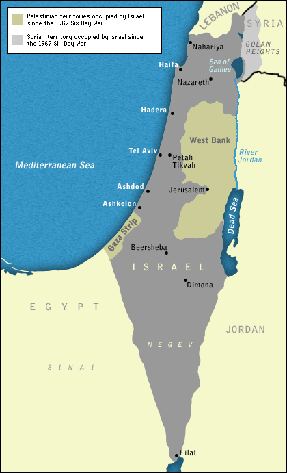
Click here for a modern map of Israel.
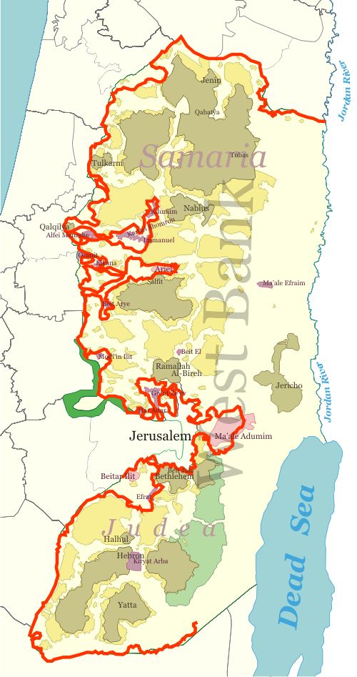
Click here for West Bank Areas A,B,C that includes Bethlehem, and the story with East Jerusalem Residents.
Click here for a link to Google Maps, showing Israel surrounded by Lebanon Syria Jordan Iraq Arabia and Egypt.
Click here for the timeline of Australia's ambassadors to Israel, based in Tel Aviv since October 1949.
Click here for a pictorial history of "Aussies" in Israel, from dfat.gov.au.
Deep inside the plucky country
The Australian
Greg Sheridan, foreign editor
January 19, 2008
IN a land of stark, powerful and sometimes bizarre images, as Israel is, perhaps the most ghostly for an Australian are the countless gum trees that populate Israel, the north especially.
Israelis brought in the gum trees to drain the swamps. Now they are not so sure whether the fast-growing and thirsty trees are an ecological plus or not. But these exotic Australian settlers in the land of the Bible are now too numerous to eradicate, and too beautiful.
Their presence is almost surreal in the much bombed and fought over land of Israel. But the gum trees are friendly, especially to an Australian visitor. It's as if a single ghost gum represents every Australian soldier who ever fell in the Middle East, through all the many decades that Australian soldiers have been fighting and dying there.
The Middle East is an indelible part of Australia's past and of its future. Our strategic engagement there is in the direct defence of our national interests, for the Middle East is the pivot of global conflict.
Three weeks in Israel recently presented a compelling series of images. Often enough it's images that are fought about in the Middle East. Yet in the context of Israel, it is seldom images of Israel that attract attention. It is images instead of the Palestinian territories. These are indeed compelling and they are among the most reported, seen and discussed images in the world. They deserve attention. But here's something else.
Alongside the territories is a much under-reported but fascinating and unique country. It's called Israel.
The world media makes a mistake by using the same reporters to cover the Palestinian territories as well as Israel. They can't do both, and most don't try to.
They cover the territories and they only cover Israel as a brooding and malign presence in the territories.
Naturally the reporting is one-sided. But it is worse than that. It omits from the equation Israel and the Israelis, and all the countless enthralling and diverse aspects of Israeli politics and society.
It is ever the fate of stable, democratic countries, even those involved in a conflict, to be under-reported. Israel was more reported a few years ago, when terrorists were murdering 1500 of its citizens a year. Now, with the security barrier, wrongly labelled a wall when it is mostly a fence, terrorist infiltration is much more difficult and perhaps a dozen or so Israelis are killed a year by terrorists.
Although Israel is a physically small country - it's one-third the size of Tasmania - most of its seven million people distribute themselves over incredibly diverse cities.
Jerusalem is an eternal city: the centre of Judaism, the fountainhead of Christianity and an important site for Islam. Visually it is stunning, its character maintained by the most enlightened civic ordinance on record: that all new buildings must be constructed of white Jerusalem stone. Like most Israeli cities it has several diverse communities: ultra-orthodox religious Jews who don't serve in the army and often don't work, Arab Muslims, Arab Christians (a small and diminishing minority), secular Jews, and national religious Jews who serve in the army and participate in the modern economy.
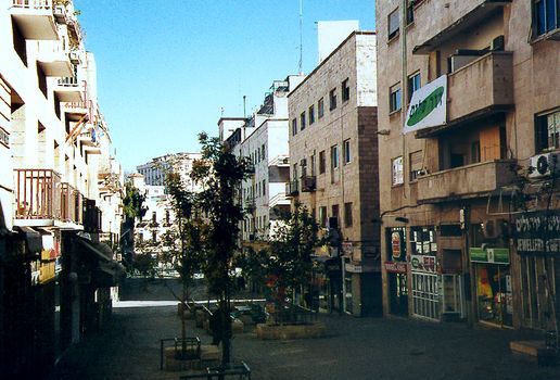
Jerusalem: This Sabbath photo is highly deceptive, since most days--and nights--the mall is crowded.
Photo: www.greatmirror.com
Tel Aviv, Israel's biggest city, is entirely different. In the Bible, it was referred to as Joppa. Today, it is a sensuous Mediterranean city that offers every decent amenity of any cosmopolitan European city. Its hedonism and its sensuousness are tempered by the strategic gravity of Israel's situation, by everyone doing their military service and by the cultural depth of Judaism, the traditions of the book. Tel Aviv is predominantly secular Jewish, with very few Arabs and ultra-orthodox Jews.
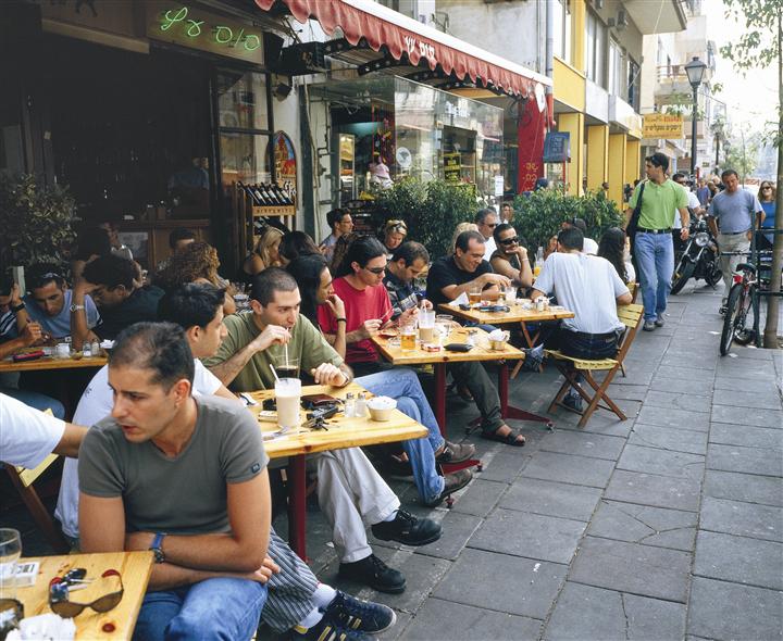
A coffee shop in Tel Aviv Photo: Israel Ministry of Tourism
Haifa, the port city to the north of Tel Aviv, is different again. It has the largest Arab minority of a big Israeli city and is where Arabs and Jews most easily and fully mix together, although such mixing occurs all across Israel. Haifa is also the world headquarters of the Bahai faith, which was founded in Iran and has suffered terrible persecution there and so has fled to two countries where religious minorities are not persecuted: Israel and India.
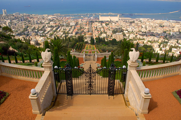
Looking from the top gate of the Gardens of Bahai, over the rest of Haifa in northern Israel and towards the Mediterranean sea.
Photo: www.trekearth.com /members/mikedeere
Israel is full of such anomalies. The Druze are a small, separate, Arab religious group found in Lebanon, Syria and Israel. Within Israel, they are fiercely loyal to the state of Israel (the Druze in Syria are loyal Syrians and in Lebanon loyal Lebanese) and serve in the Israeli army with great distinction, so that many have been represented in its most elite fighting units.
I caught a glimpse of another Muslim minority, the Bedouin, from the air when I flew in a small plane over the Negev Desert, south and east of Tel Aviv. There I spied dozens of small makeshift settlements, more or less completely outside legal regulation. But these were not the illegal Jewish settlements of media legend. They were Bedouin encampments, often of a few caravans or houses, seemingly impossibly isolated, scattered through the desert. The problem they cause is for those trying to get education and social services to their children.
To the east of the Negev, on the edge of the Dead Sea, I got an aerial glimpse of Masada, the astounding mountain-top fortress where a group of Jews made their last stand against the Roman Empire. On another day, visiting a northern part of the Dead Sea, I came upon a group of tourists cavorting joyfully in the strange, viscous, mineral-filled water. Their accents were unmistakable. They were a group of Malaysian tourists; yet Malaysian passports bear the absurd restriction that says Malaysian citizens may not visit Israel.
One night I dined at the home of a local Israeli Arab leader in the almost entirely Israeli Arab town of Abu Ghosh, just west of Jerusalem. It has always been identified with the Israeli state. My host had his complaints about the Israeli Government but he was also a proud Israeli. And every night his town, which has many restaurants, is full of Israeli Jews at the countless eateries because, and here I'll make a clear statement of cultural preference, Arab food is generally a little more interesting than Jewish food.
I spent days in the north of Israel and visited the town of Metulla, on the tiny tip of a finger of Israeli territory that juts into southern Lebanon. Until the 2006 war with Hezbollah, its people were repeatedly attacked by rockets from southern Lebanon. The municipality organised field trips away from the town for the children, but mostly the residents stayed. I visited the town's Canada Centre to try the odd practice of pistol shooting on the gun range. Here's another paradox of Israeli society. Many people have guns but it is not remotely a macho society. Its murder rate is low. Binge drinking is not part of the culture. Nobody fires a gun into the air at a wedding. Although the shortest time in Israel is between the light turning green in front of you and the car behind you honking, people don't settle traffic disputes with gunplay. Israelis argue - loudly, abrasively, obsessively - at endless length, but they seldom resort to fisticuffs.
I saw Gadot, the now disused network of bunkers and tunnels constructed by the Syrian soldiers in the Golan Heights. Before Israel seized the Golan Heights, Syrian soldiers would fire from the bunkers at workers on the kibbutz below.
But I also sought out the controversial images of Israel, in particular those of the Jewish settlements in the West Bank. A word on definitions. After the 1967 war, when Israel was attacked by a coalition of its Arab neighbours, Israel took territory in East Jerusalem, the West Bank and Gaza. Some of this, Israelis argue, is necessary for security.
It has since left Gaza. Israel is constantly urged to go back to its 1967 borders, but the two places where it has done that, in southern Lebanon in 2000 and Gaza in 2005, the result has been disastrous. It was subject to hundreds of rocket attacks from southern Lebanon until it went to war with Hezbollah in 2006 and now every day Qassam rockets are fired from Gaza at nearby Israeli civilian towns, especially Sderot.
The final borders between Israel and a putative Palestinian state have yet to be worked out. Every inch of territory with a Jewish inhabitant beyond the 1967 borders is commonly referred to as a Jewish settlement. I spent days driving up and down the West Bank and visited as many Jewish settlements as I could. These included suburbs of Jerusalem such as Gilot and Har Homa, big settlements just outside Jerusalem such as Gush Etzion and Ma'ale Adumin, and the biggest, distant settlement, the town of Ariel.
Although I think Israel will be prepared to give up numerous settlements in the West Bank, I don't think any of those named above will be given up under any circumstances. The stereotype of the Jewish settler, as columnist and author Hillel Halkin has written, is of "a belligerently bearded Jew with a knit skullcap on his head, a Bible in one hand and a rifle in the other". It's a stereotype I didn't meet at all in any of these settlements, and not for want of trying, although of course I met only a fraction of the nearly 400,000 Jews who live beyond the 1967 lines.
There are certainly ideologically militant and intolerant settlers, but they are a minority. While committed to Israel like virtually all its citizens, the settlers I met lived where they did for a variety of reasons, mainly the lower cost of housing, the communal lifestyle and educational opportunities, and sometimes because of a desire to be connected to biblical lands.
The status of the different communities routinely lumped into the single category of settlements varies enormously. Israel officially annexed some parts of East Jerusalem straight after 1967. Although there may one day be a compromise on Jerusalem, no Israeli government will give up central suburbs such as Har Homa and Gilot.
For an Australian it is almost impossible to imagine the smallness of the distances involved. Gilot was routinely fired on by snipers in Bethlehem several years ago, and so, well before the security fence was put up, Gilot had its own system of walls and shields, especially for children's playgrounds. For Gilot to be fired on from Bethlehem is like Sydney's Surry Hills being fired on from Redfern, or Richmond being fired on from the Melbourne Cricket Ground. Jerusalem, in the view of many Israelis, becomes indefensible without its Jewish suburbs developed since 1967.
The status of Gush Etzion, a little distance to the southwest of Jerusalem, is also intriguing. It was a Jewish area before 1948, when the UN divided the land of Israel into Jewish and Palestinian states, which the Palestinians and their surrounding Arab neighbours declined to accept, so that several Arab nations launched a war on Israel. The Jordanian army took control of Gush Etzion at that time.
After 1967 it was re-established as a Jewish settlement. Gush Etzion as a Jewish settlement has a 20th-century history long pre-dating 1967. Before the intifada, to get to Gush Etzion you would drive through Bethlehem. Israelis in those days commonly went to dentists in Ramallah, because it was cheaper. Hundreds of thousands of Palestinians earned a good living working in Israel.
The need to prevent terrorism has compromised everyone's quality of life. Now, to get to Gush Etzion from Jerusalem, you drive through a tunnel road. When you emerge from the tunnel, a good deal of the subsequent road is behind walls. The road is Israeli, the land on either side is Palestinian territory, and of course there are checkpoints to get back into Jerusalem as well as armed guards at the entrance to Gush Etzion.
A house in Gush-Etzion. Photo: www.gush-etzion.org.il/realestate.asp
And yet life in Gush Etzion is normal. Behind the gates people hitchhike routinely (as they do in much of Israel) because they all trust each other. On the day I visit, a group of American Jewish teenagers are there as part of a program to acquaint diaspora Jewish youth with their cultural heritage. They are the normal loud-mouthed, good natured, overbearing American kids.
The only odd thing about them is that they are accompanied by two security guards, in this case Israeli girls who look barely older than the teenagers they are guarding and carry rifles as tall as themselves.
The mayor of Gush Etzion, Shaul Goldstein, tells me that many people live there because of the availability of quality housing. They can buy a good apartment for $US200,000 ($228,000) and for a little more, a house with a garden. That's impossible in Jerusalem proper. And the settlement has renowned schools. Says Goldstein: "We thought during the intifada that people would leave. But people didn't leave. Instead they kept coming, even from Australia, even from Bondi Beach.
"One reason is the community lifestyle. People's children can walk safely from house to house. People also feel they are part of history. I'm driving to work through the path of King David. It's important to me as a religious man."
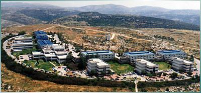
Ariel University Center of Samaria Photo: www.ariel.ac.il
The most emphatic settlement I visited was Ariel. It's a Jewish town of about 30,000 people, deep in the West Bank. Ariel University College has about 10,000 students, 3000 of them doing pre-undergraduate courses. The student population is racially diverse, as is Israel. The Ethiopian presence is noticeable. But Ariel officials tell me some local Palestinians attend as well, although of course they are under pressure not to.
Ariel is a small but substantial city. It is a beautiful place, full of public gardens and garden homes, and it has a distinctly European air and style. People don't like to use the back road to Jerusalem because even in these relatively calm days there is the danger of attacks. Just a few days before I visit, a Jewish settler, not from Ariel but from nearby, was killed on the road, as it turns out by two Palestinian Authority policemen who simply waited for a victim to come along.
I attend a seminar at Ariel on the international media's treatment of Israel. Leonard Asper, the Canadian part-owner of Network Ten in Australia, delivers an alternately witty and fiery denunciation of the media's bias and hostility against Israel. Later Asper, former Israeli defence minister Moshe Arens and I tour the university. It is doing remarkable, cutting-edge work on laser technology. It is able to do this because of the one million Russian Jewish immigrants who have come to Israel in the past 15 years. Among them were many brilliant scientists and intellectuals. Some Israeli universities were cautious about hiring them, unsure whether their budgets could sustain rapid academic expansion. Ariel went ahead and hired the best Russians it could get, and the research funds have followed.
I comment to Arens that it is a good time, a calm time, in Israel. He replies: "It is calm only because of the efforts of the Israeli Defence Forces, not for any other reason."
Of course the settlements and their future are endlessly debated in Israel, as is everything else. I left Israel profoundly optimistic about the morale of the society and the resolve of the people, but profoundly pessimistic about the peace process. If there were peace, any compromise on borders might be possible. But too many Arab leaders, and too many Palestinian leaders, are playing for the very long term and still believe that in time they will wipe Israel off the map.
Apart from the overwhelming experience of visiting the Yad Vashem museum recalling the Holocaust, the most powerful image I saw in Israel was in a small office in the Knesset (parliament) building in Jerusalem. I had gone to see Ephraim Sneh, a white-haired veteran Labour Party politician and soldier, a former cabinet minister and a former general.
He points to a picture on the back wall of his office. It is of two Israeli F-15 fighters flying over Auschwitz. "When we didn't have F-15s, we had Auschwitz," he says. His grandparents, he tells me, were killed by the Polish farmers they had paid to shelter them. You learn the lessons of trusting other people with your security.
Israel will certainly make compromises. But it will not commit suicide.
|
Addendum: Extract on West Bank fence
Amos Harel, Haaretz.com
July 14, 2009
Seven years after construction work began on the West Bank separation fence, the project seems to have run aground. Work has slowed significantly since September 2007. With fierce opposition coming from the United States, Israel has halted work on the "fingers" — enclaves east of the Green Line that were to have included large settlement blocs such as Ariel, Kedumim, Karnei Shomron and Ma'aleh Adumim, within the fence. The military has, in practice, closed up the holes that were to have led to these "fingers." But giant gaps remain in the southern part of the fence, particularly in the southern outskirts of Jerusalem, in the Etzion bloc and in the Judean Desert.
Since the cabinet under former prime minister Ariel Sharon first approved construction of the fence, in June 2002, the route has undergone some dramatic changes. The original route, which was inspired by Sharon, was to have effectively annexed about 20 percent of the territory of the West Bank to Israel.
In February 2005, the cabinet amended the route to include just nine percent of the West Bank. In April 2006 an additional one percent was shaved off by the government of Ehud Olmert.
In practice, however, the route encompasses only 4.5 percent of West Bank land. The four "fingers" in the last map (and which Israel presented at Annapolis in November 2007) were never built, not at Ariel and Kedumim (where a "fingernail" was built, a short stretch of fence east of the homes of Ariel); not at Karnei Shomron and Immanuel; not at Beit Arieh, nor south of that, at Ma'aleh Adumim. Instead, with little publicity, fences were put up to close the gaps closer to the Green Line, at Alfei Menashe instead of at Kedumim, at Elkana instead of Ariel and in the Rantis area instead of at Beit Arieh.
About 50,000 people in these settlements remain beyond the fence. West of Ma'aleh Adumim the wall built along Highway 1 blocks the gap in the barrier and leaves the city's 35,000 residents outside of the barrier, forcing them to pass through a Border Police checkpoint in order to reach Jerusalem.
Large gaps remain in the southern West Bank. Between Gilo in south Jerusalem and Gush Etzion are tens of kilometres of barrier, work on which was suspended due to High Court petitions. As a result access to Jerusalem from the direction of Bethlehem (now a part of the Palestinian Territories) is relatively easy — for commuters and terrorists both.
A second, 30-kilometre gap in the fence, stretches from Metzudat Yehuda (Yatir) in the west to the Dead Sea in the east. The state announced during a recent High Court deliberation of a petition submitted by area Bedouin that work on the barrier there was suspended.
Defence Minister Ehud Barak is "determined to complete the security fence, despite the delays," his office said in a statement. "The minister and the military establishment are working to solve the problems delaying its completion."
Defence Ministry officials pointed out that Barak was "among the first supporters of the fence and did much to advance its construction."
Security officials claim the rate of construction depends on finding a solution to the legal issues and point out proudly that there is an unbroken barrier from Tirat Zvi in the Beit She'an Valley (in Northern Israel, just west of the Jordan River) to the southern entrance to Jerusalem, and from southern Gush Etzion (south west of Jerusalem) to Metzudat Yehuda (south east of Hebron).
|
Addendum 2:
Israeli Gaza Strip Barrier
Wikipedia
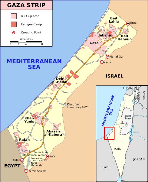
The Israel and Egypt - Gaza Strip barrier is a separation barrier first constructed by Israel in 1994 between the Gaza Strip and Israel. An addition to the barrier was finished in 2005 to separate the Gaza Strip and Egypt. The fence runs along the entire land border of the Gaza Strip. It is made up of wire fencing with posts, sensors and buffer zones on lands bordering Israel, and concrete and steel walls on lands bordering Egypt.
Background: The Gaza Strip borders Egypt on the south-west and Israel on the south, east and north. It is about 41 kilometres long, and between 6 and 12 kilometres wide, with a population of about 2.3 million people. The shape of the territory was defined by the 1949 Armistice Agreement following the creation of Israel in 1948 and the subsequent war between the Israeli and Arab armies. Under the armistice agreement, Egypt administered the Strip for 19 years, to 1967, when it was occupied by Israel in the 1967 Arab-Israeli War.
In 1993, Israel and the Palestinian Liberation Organisation signed the Oslo Accords establishing the Palestinian Authority with limited administrative control of the Palestinian territories. Pursuant to the Accords, Israel has continued to maintain control of the Gaza Strip's airspace, land borders and territorial waters. Israel started construction of the first 60 kilometres long barrier between the Gaza Strip and Israel in 1994, after the signing of the Oslo Accords. In the 1994 Interim Agreement on the West Bank and the Gaza Strip, it was agreed that "the security fence erected by Israel around the Gaza Strip shall remain in place and that the line demarcated by the fence, as shown on the map, shall be authoritative only for the purpose of the Agreement" (ie. the barrier does not constitute the border). The barrier was completed in 1996.
The barrier was largely torn down by Palestinians at the beginning of the Al-Aqsa Intifada in September 2000. The barrier was rebuilt between December 2000 and June 2001. A one-kilometre buffer zone was added, in addition to new high technology observation posts. Soldiers were also given new rules of engagement, which, according to Ha'aretz, allow soldiers to fire at anyone seen crawling there at night. Palestinians attempting to cross the barrier into Israel by stealth have been shot and killed.