The population of Australia at the time of its "invasion" by England in 1788 is estimated at perhaps being about 1 million though it may well have been less. The population around the Sydney region was estimated as "about 1500". From the beginning, instructions from England were to "establish good relations with the Indigenous people" in order to "gain useful knowledge of the area", and all reports of Governor Phillip show that, yes, he endeavoured to do just that, ordering that the Aboriginal peoples must be "well-treated, and that anyone killing Aboriginal people (without due cause - Steve) would be hanged". But in 1791, Governor Phillips handed out muskets to ex-convict settlers, to "shoot at" aboriginals, and inevitably settler and government retaliation against aboriginal attacks led to unpunished massacres.
Year of last massacre by State (according to Wikipedia)
There were no (or minimal) land sales before 1831. Transportation to Sydney ended in 1840 as the colony opened up to free settlement, land sales (by auction), and subdivision. Self-government in NSW came in 1855.
Independent colonies opened up under British rule, starting with Hobart in Van Diemen's land in the south in 1825.
By the time transportation ended in 1868, the number of convicts is said to have totalled perhaps 164,000 with that figure including some internal transfers and local convictions. It has been estimated that almost two-thirds were English, though that figure included about 5% who were definitely Scots and perhaps 3% Welsh, with the other one-third coming from Ireland. Of their initial destinations:
A database of 123,000 names has been located of the British transportation registers, for downloading from Sheffield University, a .csv file that opens in Excel. Or click here to download it as a compact file, sorted by transportation year, showing just convict name and initial destination.
Over the waters from Sydney in 1834, James Busby, the official British Resident in New Zealand, drafted a document known as the "Declaration of (sovereign) Independence" of New Zealand, under the protection of the British Crown, which he and 34 northern Maori chiefs signed at Waitangi on 28 October 1835. Back in 1769-1770 James Cook, followed by English missionaries, had started transcribing the Maori language into the English script, a development embraced enthusiastically by Maoris during the 1820s. By 1839, 52 chiefs had signed.
In 1907 the Colony of New Zealand changed its rank to that of a Dominion within the British Empire. Since the reign of Queen Elizabeth II, "Commonwealth Realm" is the term used.
Federation in 1901 now declared Australia's colonies to be self-governing states inside the Commonwealth of Australia, with the Australian constitution recognising the principal of "separation of powers" i.e. having three branches of government 1. Parliament: Making laws, with Parliament always subject to the Constitution 2. Prime Minister and the Cabinet: Enforcing laws 3. High Court Judges: Interpreting laws in light of the Constitution. The Constitution cannot be changed by an Act of Parliament alone, a referendum of the people is necessary. The change must receive majority support in a national vote, and also majority of support in a majority of states i.e. at least four of the six states.
Click here for further background to this Australian system of government.
In 1948, the issue of becoming an Australian citizen, and having an Australian passport, arose. Prior to 1947, all peoples who lived under British protection by descent in the Commonwealth of Nations, including indigenous peoples in India and Australia, were entitled to British citizenship and to a British passport. This situation could no longer apply to subjects in the brand new Republics of India and Pakistan, at that time suffering from partition, population transfer, and violence.
Rules have evolved somewhat. The other situation after 1949 of being an Australian citizen, and thus becoming a British subject was then acknowledged by the UK up to January 1983, but rarely since.
On 26 January 1984, all British subjects in Australia who were not Australian citizens became known as "permanent residents". If registered to vote, they were allowed to retain that right, but after that date the right to vote was only to be granted to Australian citizens.
At the same time, the residence period for naturalisation was reduced from 3 years to 2 years, though after 2007, it was increased to 4 years.
In 1992, in a High Court decision akin to New Zealand's formal declaration of historic land rights, the Murray Island decision asserted that "Native Title" pre-existed prior to 1788 for community governance purposes, and rejected the use of "Terra Nullius" inferred in an earlier 1971 decision by the Government of Queensland. Referred to as the "Mabo decision" after the trade union leader who had taken this case up to the High Court. Famously alluded to in "The Castle", a movie filled with Australia's talent at "sending itself up".
...
Terra Nullius — its background
- Terra is the Latin word for land (in general)
- Territorium is more specifically, the Latin word for the land around (or sometimes within) the boundaries of a town i.e. its territory
- In 1888 "Territorium Nullius" - nobody's territory - was first used as a Latin expression at the Berlin conference in Germany in reference to unclaimed territory around settlements in Africa
- In 1909 "Terra Nullius" - nobody's land - referred to an unclaimed polar region known as Svalbard by Camille Piccioni. Today polar regions are the subject of ongoing disputes by Russia, Canada, Denmark and Norway
- In 1992 "Terra Nullius" became a straw man argument made by Eddie Mabo's lawyers with specific reference to the Torres Straits Islands, claiming that the Queensland Government in 1971 had used the context of "Crown Land" to infer a prior "Terra Nullius" or "Nobody's Land" situation was applicable when James Cook made that declaration in 1770 at Cape York "claiming the territory of New South Wales in the name of the British Crown". But the land was occupied.
So as a "straw man" argument in 1992, it could immediately be demolished by lawyers.
However, back in 1770 the British Empire, the French Empire, the Prussians the Russians and the Chinese were major world-wide institutions. The British Government knew that the occupants of the land were entitled to Common law rights, and that Cook's declaration would inevitably involve granting them their rights. The situation then was more complicated than a Polar region "Terra Nullius" debate.  And on many levels the situation still is today. A kingdom, an empire, a nation divided against itself cannot stand. Matthew 12:25
Back to the 1800s. As far as "becoming free" of Sydney's oversight and control went, dates of independence (which made them answerable to London, not Sydney) followed by self-government were as follows:
There was no standing army. Defence of the Australian colonies was mostly provided by British Army regular forces. Native "police" would round up convict runaways, being rewarded with tomahawks and blankets. After convict transportation ceased, each colony became responsible for the appointment of Police officers under a Commissioner of Police. South Australia was first to do so in 1840, Victoria and Western Australia followed in 1853, NSW in 1862, Queensland in 1864, Northern Territory in 1870, and Tasmania in 1899. British military support now ended with the departure of the last British Army regiment in 1870. Colonial military forces formed in each colony, by 1885 they numbered 21,000 men. Not a lot has changed in those numbers between then and now, in 2019 the Australian Army reported 29,511 regulars (i.e. full-time) and 18,738 active reserve (part-time). Britain's Royal Navy continued to provide protection for the waters around the continent, until Federation in 1901. The Anglo-Japan alliance a reduced Pacific presence followed in 1902.
PNG 9 million NZ 5 million.
Ok. Now for Brisbane and Queensland, initially the Moreton Bay settlement.
Apparently the number increased to 983,000 in the 2021 census, with perhaps 100,000 of those names in the south-east of Australia self-identifying for the first time.
Queen's Wharf Precinct Resort Development and recent news Star Entertainment
Sir George Bowen, the first governor of Queensland, in a letter to a friend in England in 1859
http://espace.library.uq.edu.au /eserv/UQ:212643 /s00855804 1962 1963 7 1 72.pdf
"Brisbane, my present capital, must resemble what Boston and the other Puritan towns of New England were at the close of the last century. In a population of 7,000 we have fourteen churches, thirteen hotels and twelve policemen. The leading inhabitants are a hard-headed set of English and Scottish merchants and manufacturers." Writing to the Secretary of State for the Colonies he also described himself as impressed by the air of prosperity. "Distress and pauperism, those comprehensive terms so frequently used in European politics, are unknown here."
Despite this favourable view, it is recorded that one other visitor at another time was not so impressed. When he saw the hotels, he rubbed his hands with glee, saying this was the place for him to start in business. But then he counted the churches — and returned at once to Sydney.
Queensland, a Brief Timeline of its Regulations and Laws
LGA Local Government Areas
Qld Government Factsheet
- 1859 First municipality Brisbane with 5,000 people. Mayoral elections yearly in February male ratepayers over 21. Until 1871 multiple registration/voting was possible through multiple properties. Qld elections five-yearly all male residents. Colony 16 Districts and 26 similar-size Members, non-compulsory vote, first past the post
- 1860 Ipswich Toowoomba Rockhampton follow as municipalities
- 1861 Maryborough and Warwick now municipalities
- 1862 Registration New Land (Torrens title) now compulsory
- 1863 Gladstone Bowen and Dalby become municipalities, Townsville 1866, Roma 1867, Mackay 1869, Charters Towers 1877.
An Act in 1864 enables all councils to charge rates, borrow money, enact bylaws, regulate public infrastructure and utilities, and provide public amenities e.g. gardens and hospitals.
Brisbane's six Councillors elected for 3 years, with one-third of the wards retiring annually and councillors electing the mayor annually
- 1878 Act divided all LGAs not in municipalities into 74 divisions, each governed by a Board of between 3 and 9 members who elect their Chairman (called "Mayor" since 1993). Elections conducted by postal ballot, female ratepayers now eligible
- 1885 Qld law passed awkwardly excluding full "aboriginal natives" from vote. Not reversed till 1965
- 1893 Qld elections now held three-yearly and optional preferential voting introduced
- 1902 With Federation and the Commonwealth's new Electoral "Divisions", Queensland renamed their LGA "Divisions" as Shires, Municipalities as Towns, South Brisbane and Brisbane as Cities
- 1905 State law passed making women eligible to vote
- 1910 One District One Member rule, now 72 seats
- 1911-1912 Compulsory enrolment of eligible voters was passed by Federal Parliament in Melbourne in December 1911, and formally commenced on 27 March 1912. Enrolment forms could be found at each State Govt electoral office or local post office. Previously, police and electoral officers were responsible for keeping tabs on each state's eligible voters, a big job
- 1915 Voting made compulsory in Qld elections, first state to do so in Australia
- 1920 Voting made compulsory in local elections, not just ratepayers. Mayor now elected directly by citizen vote. Council elections every 3 years, not one-third yearly
- 1922 Upper House abolished in State Parliament
- 1925 Brisbane and South Brisbane amalgamated with six towns and twelve shires on state district boundaries, forms a 20 ward "super council", reduces the number of councillors from more than 200 down to 20
- 1942 First past the post voting reintroduced
- 1962 Compulsory preferential voting introduced
- 1971 Following 1965's reversal of 1885's law, indigenous enrolment and voting compulsory
- 1973 Adult voting age changed from 21 to 18
- 1991 Optional preferential voting reintroduced
- 2000 Local elections four-yearly, last Saturday in March
- 2004 Brisbane 26 wards
- 2008 Qld 77 LGAs
- 2016 State 93 seats, + full preferential voting, four-yearly, last Saturday in October
Return to Table of Contents
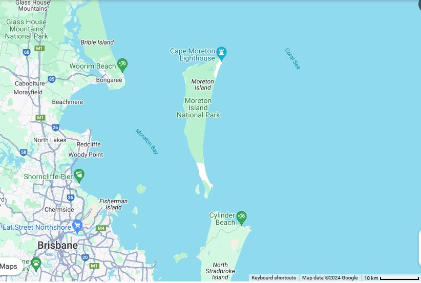
Brisbane's First Explorers, Pamphlett, Parsons and Finnegan
http://nla.gov.au /nla.obj-62201287 /view?partId=nla.obj-62214594#page/n0/mode/1up
Prior to 1823
In 1770 James Cook named Moreton Bay (spelling it as "Morton"). A misprint, however, introduced the "e". In 1799 Flinders also explored the area, more closely. In 1822 John Bingle and William Edwardson explored in the area. But all these navigators missed any indication of a large river entering Moreton Bay.
Lost and Shipwrecked
Thomas Pamphlett and fellow "ticket of leave" convicts Richard Parsons and John Thompson, along with full convict John Finnegan, were hired by settler William Cox to fetch cedar from the Illawarra District, the Five Islands, now known as Wollongong, south of Sydney. They set sail on their maiden voyage on 21 March 1823 in an open boat 29 feet in length and 10 feet in beam. On board were large quantities of pork and flour and five gallons of rum to buy cedar from the timber cutters, plus four gallons of water.
They got to within sight of Illawarra when a strong breeze blew them away from the coast. The wind became stronger, heavy rain fell and it got dark. They were blown further out to sea. It was five days before they could use any sail, and they drank the water and the rum. Prevailing winds and currents may have taken them most of the way across the Tasman Sea toward New Zealand. They were hopelessly lost. In error, they thought they had drifted south to Van Diemen's Land (Tasmania) so they headed northwest to try to get back to Illawarra and Sydney. On their twenty-second day at sea, having survived on just rum and salty rainwater, Pamphlett spotted land. Before they could land, Thompson succumbed to the lack of fresh water and the elements, and collapsed and died. But scared of the natives they saw in their weakened condition, worried about wrecking the boat, arguing, they sailed north with his body for three days until, delirious with thirst, Thompson was dropped overboard, and the others landed, wrecking the boat.
|
Moreton Island
Pamphlett, Finnegan and Parsons had landed on Moreton Island, just north of the Brisbane River. Thinking Sydney was well to the north, they set off along the beach in this direction with two sacks of flour and a few other items. They spent the next seven and a half months walking around Moreton Bay, island hopping, and following river and creek banks until they could find a way of crossing them. They lived for periods with several Aboriginal tribes who fed them fish and fernroot and thought they were the ghosts of dead kinsmen due to their pale colour.
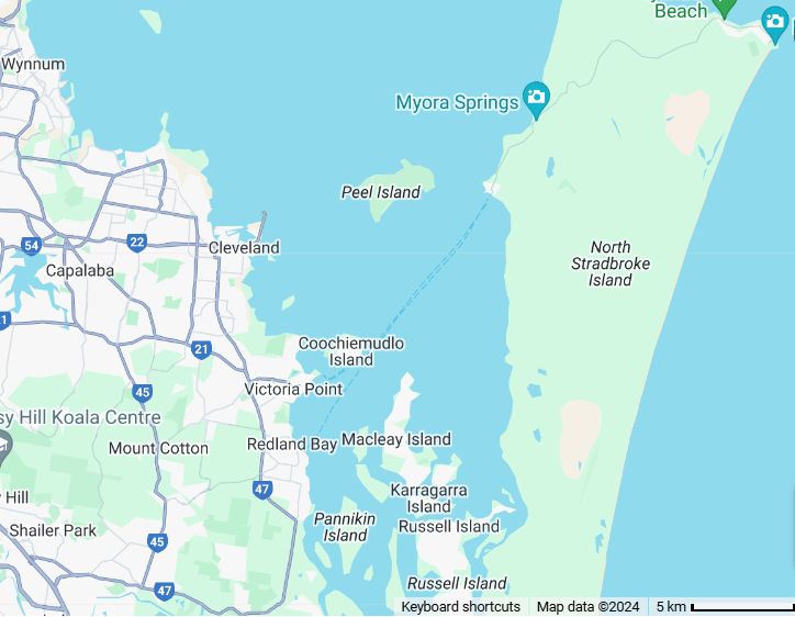
Stradbroke Island and Cleveland
The natives first took them south by boat to Stradbroke Island. Here the castaways made their own canoe and got to the mainland, where they landed near what is now Cleveland. They continued their journey northwards along the waterfront in hope of reaching civilisation. It wasn't long before the trio stumbled across a large river which they were unable to cross, the Brisbane River. They trekked upstream for almost a month, weakened due to lack of good food. With only one reasonable swimmer (Pamphlett), they had to follow the banks of many of the creeks they encountered en route. Upon reaching Oxley Creek near Tennyson, they found a canoe. The canoe was on the western bank of the north-south running creek, and was procured by Pamphlett swimming across the creek and bringing it back, though it could not support more than two of them. So they used the canoe, and another they saw on the north side of the large river, to finally cross it, return to its mouth, and continue north, reaching Bribie Island at the start of July 1823 where they stayed with a tribe for about a month. Then they set out again, north.
At the Mooloolah River, Pamphlett was encouraged to return to live at Bribie Island with an Aboriginal friend whom he had helped, after he had extracted part of a spear that had been broken off inside his leg a month earlier. Parsons and Finnegan headed further north. The pair quarrelled, Parsons threatening to murder him with his knife, and Finnegan returned to Bribie Island to Pamphlett and the tribe. Parsons continued northwards.
Rescued
On 29 November 1823, Pamphlett and some Aborigines were on the beach at Bribie Island cooking the day's catch when he saw a cutter in the bay. It was explorer John Oxley who was returning down the coast, from two weeks at Port Curtis near Gladstone, looking for a new convict settlement. Oxley was amazed to see and hear a "lighter-skinned" man waving and hailing him in English with the natives, Pamphlett himself could hardly speak that evening, such emotion, relief. But only then did Pamphlett learn that Sydney was over 500 miles (800 km) to the south rather than to the north. He told part of his story to crew member John Uniacke. Next day they picked up Finnegan who was returning from a tribal fight. Finnegan showed Oxley the Brisbane River hiding behind the mangroves and Fisherman's Island , while Pamphlett assisted Uniacke and others with aspects of Aboriginal culture. After Parsons returned to Moreton Bay, having as Parsons said later, walked for "hundreds of miles", he was picked up by John Oxley on his third trip with Governor Brisbane and John Finnegan in November 1824.
Oxley, having sailed up the Brisbane River as far as Goodna in 1823, was adamant the bay and the river, was the place to start the settlement.
Return to Table of Contents
First Settlement
Convict_buildings (arch.)
http://gutenberg.net.au /ebooks14/1400241h.html
September 1824: Following Oxley's recommendation, first convict settlement was in Redcliffe, having slab huts for the 29 convicts. It was later renamed Humpy Bong ("Dead Huts") by the natives. The land was found unsuitable for grain, also too much disease and mosquitoes (and theft from natives). This was Oxley's second trip, made with Allan Cunningham, when he had breakfast at Breakfast Creek. On November 23, Governor Brisbane arrived with Oxley on his third trip, to see this river.
In January 1825 Oxley, with Governor Brisbane's approval, recommended Breakfast Creek become the new penal site. But in February Commandant Henry Miller in Redcliffe overruled them, with the transfer in May to North Quay. At the end of 1825, the population including the soldiers was 45 males and 2 females. Convict numbers increased rapidly, reaching 1,241 by 1831. Over the length of the convict period, 2400 convicts arrived, including 144 females. As a place for hardened criminals and repeat offenders the principal object of the authorities was the isolation of the settlement, approach to which within fifty miles was strictly prohibited to Europeans.
So naturally there were no shops or banks. Fresh water came from a creek which rose near the present Brisbane Grammar School on Gregory Terrace and flowed down the site of Roma Street Parkland to the site of the present City Hall. A small reservoir dammed this creek and conveyed water through hollow hardwood logs. Corn, the first successful staple crop, was grown at South Brisbane, directly opposite the main settlement. New Farm followed in 1827, Eagle Farm in 1829.
1827: Limestone Station (later renamed as Ipswich) provided the source of Brisbane's mortar for its convict hospital built in 1827, the male and female convict barracks in 1828-29, the Windmill to grind corn on Wickham Terrace in 1829, plus the brick Commissariat Store at the Queen's Wharf Rd, back then the King's Jetty, in 1828-29.
The convicts' hours of work were sunrise to sunset with two long breaks, one at 8am for breakfast and one at midday. On Sundays, they were mustered for a church service. Hundreds of convicts fled the stern conditions (of public lashings and at times executions) and escaped into the bush. The convict settlement was gradually reduced during the 1830s as the authorities prepared to open the Moreton Bay region for free settlement.
1834: With numerous stone structures now built, the Moreton Bay settlement was declared to be a town having the name of Brisbane being on the Brisbane River — that name had been given to the river by John Oxley when he explored it in Nov 1823, Sir Thomas Brisbane being the governor of NSW at that time.
1839: Penal settlement closed with convicts returning to Sydney. A number of convicts with guards remained to do maintenance and to assist surveyors. Click here for further details of this time.
1842: Brisbane was officially proclaimed a free settlement on 4 May 1842. Brisbane was laid out in dusty, unsealed streets and blocks with names derived from British royalty, Queen Victoria's uncles aunts father husband & daughter. Dr Stephen Simpson, a homeopathic surgeon, was appointed commissioner of crown lands for the area and became acting administrator until the arrival of police magistrate John Wickham the next year. On 7 December the first Brisbane land sales (by auction) were held in Sydney. The same month saw the inauguration of the first steamship service by the Hunter River Steam Navigation Co. with the steamer "Shamrock", a three day journey between Brisbane and Sydney.
Return to Table of Contents
Brisbane First Maps and Early Buildings and the Great Brisbane Fire
https://en.wikipedia.org/wiki/ Early_Streets_of_Brisbane
Below is a map of Queen Street (though not to scale) with all its buildings and landmarks in 1844. Note that the map is facing towards the south west, with the Botanic Gardens (then known as the Government Gardens) on the left and the Windmill (on modern day Wickham Terrace) on the right.
Four Numbers not clearly shown are
1 Andrew Petrie's large house at the bottom of the map to the right of Queen Street
4 Two houses belonging to Bensteads the sawyers just above 3
45 Saw Pits on the river's edge at the bottom of the map to the left of Queen Street
48 First Tombstone (two graves) at the top right (left of 17) was very likely the burial place of the 3 or 4 children who died during the colony's early years. They were reinterred with their memorial stones in the Toowong Cemetery about 1881.

- Andrew Petrie
- Handel, cattle drover
- Savory (the only baker)
- Bensteads, sawyers
- T. Richardtson (the only general store)
- Convict Barracks
- W. Kent (druggist shop)
- Fitzpatrick (the first Chief Constable)
- The Lock-up
- The Constable's place (only two in all)
- Slate's Post Office (old)
- Slate's Pineapple Garden
- Church of England
- The Hospital
- Mort, milkman
- Wright's Hotel
- General Cemetery
- Tread and Windmill
- Edmonston.s Paddock
- Old R. Jones
- Dr. Simpson (the first Commissioner)
- Old Major Prior
- The Gaol
- Skyring's Beehives (soft goods shop)
|
- Hayes, milkman
- Brothers Fraser (first houses)
- Catholic Church
- McLean's Blacksmith's Shop
- Edmonston's butcher
- Bow's Hotel
- Taylor Shappart
- Montifeur (a financier)
- W. Pickering
- Sergeant Jones
- Soldiers' Barracks
- Officer de Winton
- Commission Stores
- Queen's Wharf
- Captain Wickham's office
- Commissioner T. Kent
- Commissioner's Garden
- Captain Coley
- Government Gardens
- Father Hanley (the only priest)
- Saw Pits
- Queen Street
- The Boat House and Boatman's House
- The First Tombstone (two graves)
|
Andrew Petrie was an early builder and architect who became the Clerk of Works in the new settlement. His house on the right of Queen St at the bottom of the map (location 1) is today's Aurora Tower on the corner of Wharf and Queen Streets. Opposite came Brisbane's first customs house built at Petrie Bight in 1850. Note, port facilities are now handled by the Port of Brisbane at the mouth of the Brisbane River, and with all customs border policy and taxation now handled in Canberra, this office was closed in 1988.
Andrew Petrie's cousin George Edmonstone (from an early pioneering family, click to see an article in uq.edu.au) became the first butcher (and later on a mayor) in Brisbane. See Edmonstone's Paddock above (location 19). Andrew's son John followed in his father's footsteps as a builder, and also became mayor, in early Brisbane.
Brisbane's First Cemeteries
- The General Cemetery (location 17) in the upper right of the image was Brisbane's burial ground between 1825-1843 during the days of the convict settlement, and shortly after. During this period there were 265 recorded deaths, 220 convicts and 45 others, most of whom were buried here. After its closure in 1843 it rapidly fell into ruin with 90% of its headstones and monuments removed. Between 1864-1875 Skew Street was built over the land, joining Roma Street to North Quay.
- The North Brisbane Cemetery also known as Milton Cemetery and Paddington Cemetery operated 1843-1875 in the area now known as Lang Park (Suncorp Stadium), during which time up to 10,000 people may have been buried there. It was not a single cemetery, but rather a collection of cemeteries operated by different religious denominations.
In 1875 it was replaced by Toowong Cemetery. Similar to the first cemetery, by 1907 the land had become a community eyesore, and in preparation for it becoming Lang Park (initially an athletics field) a number of families in 1913 paid for the removal and reinterring of their family members. About 500 headstones were removed to a memorial area by the Church of England.
Early Church (St Stephen's Cathedral)
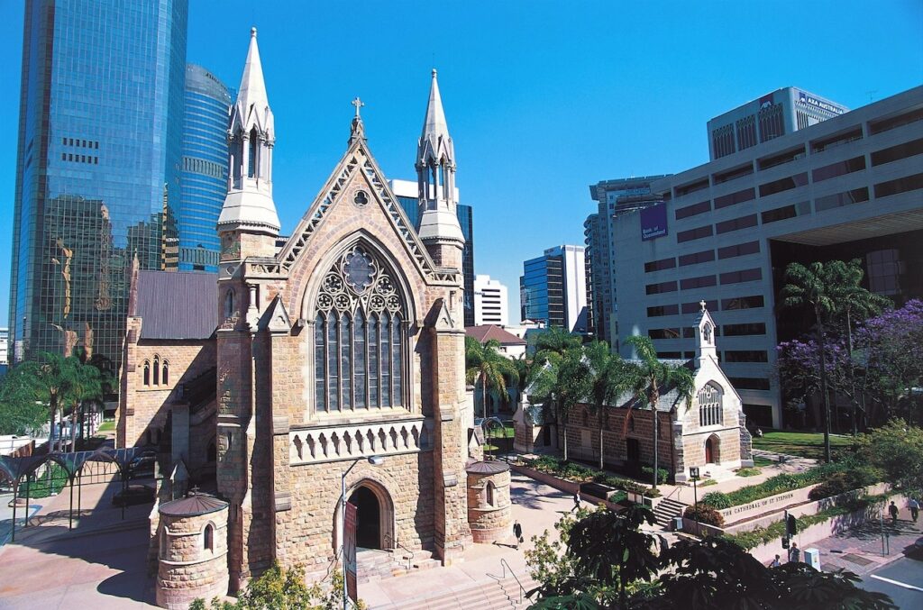 St Stephen's Chapel, also known as the Pugin Chapel, and formerly known as Old St Stephen's Church, was built between 1847 and 1850 on the site of what is now the Cathedral of St Stephen at 249 Elizabeth Street, Brisbane.
It opened with a congregation of 60 families in 1850 and it became the first Catholic Church in Queensland, after separation from New South Wales.
The present Cathedral of St Stephen nave was finished in 1874 after eleven years, with its first Mass celebrated on 17th May.
Click here for its current web page.
Click here for a recently published page of church properties in Queensland, listed by denomination.
First Courier Mail (Newspaper)
Back to 1846: Brisbane(arch.) declared a Port of Entry and Clearance. A cottage beside Andrew Petrie's house was set aside for William Duncan, first customs officer and his family.
Estimated population is 4000 Aborigines and 2257 migrants. Brisbane now consisted of three villages, at North Brisbane, South Brisbane, and Kangaroo Point.
Moreton Bay Courier, forerunner of the Courier Mail, commenced this year (1846) making frequent mention of local indigenous people who were working and living in the district.
In December, Brisbane's first solicitor Robert Little arrived and set up an office in George Street, opposite the old hospital. Click here for a detailed record of the early years of his practice. In 1925 his firm became Feez Ruthning and Co and since 1996 part of Allens Operations Pty Ltd.
1850: The first bank, the Bank of NSW opened a branch for general (trading) bank business. During the 1850s the Commissariat Store, soon to be called the Colonial Store, had its first floor turned into an immigration barracks, and in the 1860s a police barracks.
Below is Slater's pocket map of the city of Brisbane in 1865 as stored in the National Library of Australia. Click here to see its reference, with an option to download a much larger TIF file.
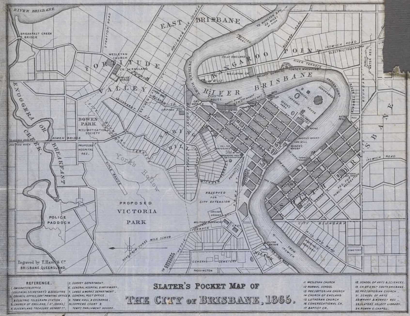
- York's Hollow (Victoria Park) was a humorous early settler reference to Daki Yakka, called the "Duke of York", being an aboriginal elder with a somewhat "regal" bearing.
It was a time when there was a fair amount of animosity between black and white (still is, in some places). Despite community disapproval, prostitution outside the hotels by underage indigenous girls who were after smokes and drinks continued to increase. So, similar to the other colonies in Australia, starting in 1855 and lasting about 100 years, it now became illegal for indigenous peoples to venture inside the "boundaries" of the Brisbane settlement after curfew i.e. after 4pm in the afternoon or at any time on Sundays. The boundary was a fence-line along Boundary Street that separated the northern area from the built-up area south to the river. In South Brisbane it was Boundary Street in the west, Vulture Street in the south and Wellington Road in the east. Similar "boundary" streets were developed around other shires and towns. After 1897, many Queensland aborigines were forced to live on "protected" reserves, with many restrictions. For example, indigenous women were prohibited from marrying anyone other than an indigenous man without the permission of Aboriginal "Protectors" with mothers having to put mixed-race children up for adoption. It was 1984 before these laws were ended.
- Fortitude Valley was an early "boat people" place in 1849. The Fortitude and two other ships were ships chartered in England by 550 migrants after a Presbyterian minister who was also a member of NSW Parliament, Mr John Dunmore Lang of Lang Park fame, told them he had been given the promise of free pastoral land on their behalf by Governor Gipps, Gipps subsequently disavowing any such statement. In some desperation, tents were set up for them at York's Hollow (Victoria Park) by Captain Wickham in Brisbane, and gradually the migrants found themselves work, both in Fortitude Valley, and elsewhere.
- East Brisbane was shifted over the river when the East Brisbane tramway route and East Brisbane Bowling Club were set up at Mowbray Park on the south side in 1903-4. On the north side it resumed its earlier name of New Farm.
- Click here for a page with further information on renamed suburbs and streets in Brisbane.
Great Fire of Brisbane
Slater's map was printed just after the Great Brisbane Fire in the evening of 1st December 1864, with entire blocks destroyed with their timber buildings, mainly in Queen, Albert, George, and Elizabeth Streets. Most fortunately there was no loss of life, and only four people were taken to hospital with injuries. Subsequently, the rebuilding of Brisbane City used more stone and brick.
Brisbane Markets
Next to Customs House in Slater's map can be seen Raff's Wharf, USN United Steam Navigation Company Wharf providing a mail service to Gladstone & Townsville and Market Wharf. Brisbane_Markets(arch.) opened in 1866 at Market Street as a major venue for where farmers could bring their merchandise to sell to cityfolk. Activity waned however, and after 1881 only the street name survived.
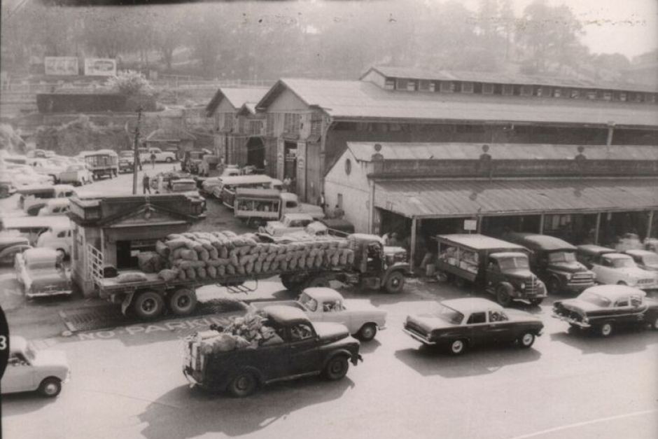
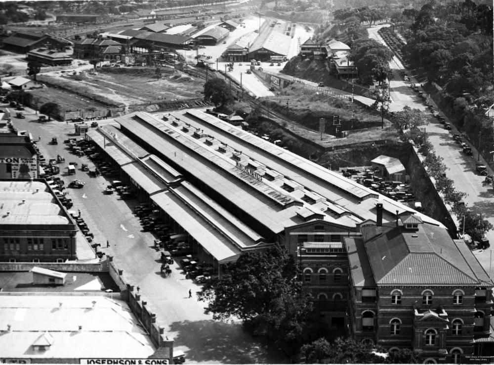
In 1885 Brisbane Markets opened at a more central location on Roma Street, that triangle of ground where Roma Street meets Albert Street at the corner of Turbot Street. Click images on right for a larger image. A separate, competitive marketplace later opened on Turbot Street.
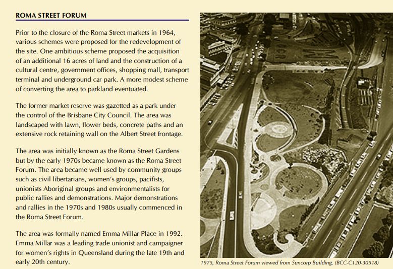
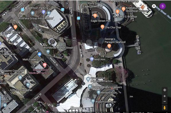
In 1964 the Brisbane Markets shifted to Rocklea and the Roma Street Markets became Roma Street Forum, and since 2001, Roma Street Parklands. Click here for a larger image.
Return to Table of Contents
First Hospital
Brisbane_hospitals (arch.)
1827: As mentioned previously, in 1827 a Convict Hospital was built on North Quay facing George Street between Adelaide and Ann Streets in this tiny convict town. In 1832 its accommodation was extended, a cottage was built for the Medical Officer, and a Military Hospital was built adjacent to it. It subsequently became the Survey Office.
1849: After free settlement, the first Public Hospital in Brisbane, the Moreton Bay Hospital, was established on 12 January, 1849. It was this old Convict Hospital on North Quay and was grossly overcrowded trying to cater to the growing population of post convict era Brisbane and surrounding areas. The hospital operated on subscriptions from those in the community who could afford to give. In turn these subscribers were issued with tickets which would entitle the bearer to medical treatment at the hospital. Those who could not afford the subscriptions and needing treatment went in search of tickets from benevolent subscribers. Another source of funds was the fines levied in the Police Courts.
1856: Brisbane's non-indigenous population approached 6,000. The name of Moreton Bay Hospital was changed to the Brisbane Hospital as other hospitals in various towns opened. The opening of other hospitals meant that the subscriptions base dwindled and a call went out for more local subscribers. Epidemics of diseases brought in from the tropics swept through Brisbane such as malaria, dengue fever, typhus, typhoid, amoebic dysentery and smallpox. Gunshot wounds and knife injuries from numerous bar and street brawls requiring surgery, were on the rise. In the 1860s tropical diseases were introduced by the 60,000 or so South Sea Islanders or Kanakas, many of whom were 'Blackbirded' and brought to Brisbane and northern Queensland where they worked on cotton plantations and cane fields. The practice was outlawed by the Queensland Government in the 1890s and most Islanders were sent home.
But it was a wild time all right. Click here re Patrick Mayne, the "mad" Irish butcher of Queen Street, at his death possibly one of the richest men in Brisbane.
1867: More than 35,000 flocked to Brisbane between 1860-1865, following separation from NSW in 1859 combined with the development of a proper immigration scheme, but with no support from the previous New South Wales government, the building of a larger hospital was delayed until the Queensland Government accumulated sufficient funds of its own. The new hospital was completed in 1867. Standing on land at Herston, the facility contained Fever Wards, long low blocks located just behind the main building. The patients were moved from the hospital in George Street to the new Brisbane Hospital on 8th January, 1867. There were complaints that the new hospital was located too far out of the town and would have been better sited at Spring Hill or Petrie Terrace. The first nurses graduated from the hospital in 1888.
Return to Table of Contents
First Gaol
Prior to the building of Brisbane's first gaol, after 1839 prisoners were housed in the military barracks in Queen Street.
- Brisbane Gaol 1850-1860 was built in Queen Street by the NSW Government on what is now the site of the GPO Post Office. Previously it had been the Female Factory, where women convicts worked during the day.
- Petrie Terrace Gaol 1860-1883 was built by the newly formed Queensland Government, becoming the Police Barracks after Boggo Road Gaol was built.
- St Helena Island Prison 1867-1933 a few kilometres from the mouth of the Brisbane River became a notorious "hellhole" for prisoners.
- Boggo Road Gaol 1883-1989 on Annerley Road at Dutton Park became Brisbane's main gaol for over 100 years.
- Brisbane Correctional Centre 1988-today. Based at Wacol with a capacity of 558.
- Brisbane Women's Correctional Centre 1999-today. Based at Wacol with a capacity of 270.
- Wolston Correctional Centre 1999-today. Based at Wacol with a capacity of 600 as a "protection" prison for sex offenders and high-profile prisoners.
Click here for Wikipedia's list of prisons and remand (detention) centres throughout Queensland.
Return to Table of Contents
First Mayor(s) of Brisbane and Premier(s) of Queensland
https://en.wikipedia.org/wiki/List of mayors and lord mayors of Brisbane
https://en.wikipedia.org/wiki/Premier of Queensland
1859: The Municipality of Brisbane was gazetted on 25 May 1859 and proclaimed by the Governor of New South Wales on 7 September 1859. The first local government area in Queensland, Brisbane was the only one incorporated prior to the establishment of Queensland as a separate colony. Its boundaries covered the Brisbane City area, and Fortitude Valley. The first election for this municipal council was held on 13 October 1859. There were 37 candidates for the nine positions on council. John Petrie, notable builder and stonemason, was unanimously elected first mayor. The first aldermen were men who had helped to establish Brisbane as an important settlement in the north.
At the same time, Sir George Ferguson Bowen was appointed the first Queensland governor. He arrived at Brisbane from England on 10 December 1859 and brought Robert Herbert with him as his private secretary. On the day of the governor's arrival, Herbert was gazetted as colonial secretary with Ratcliffe Pring as attorney-general. These with the governor formed an executive council to which additions were made afterwards. At the election held early in 1860 Herbert was returned unopposed for one of the Leichhardt seats in the Queensland Legislative Assembly and became the first premier of Queensland. He showed himself to be a good leader, holding office from December 1859 to February 1866.
Return to Table of Contents
First Water Supply and Sewerage
http://blogs.slq.qld.gov.au /jol/2014/05/13/water-for-a-thirsty-city/
https://en.wikipedia.org /wiki/Outhouse#Australia and New Zealand
https://en.wikipedia.org /wiki/Water supply and sanitation in Australia#Brisbane and Gold Coast
https://en.wikipedia.org /wiki/Queensland_Urban_Utilities
https://en.wikipedia.org /wiki/Seqwater
Click here for background and photos of Brisbane's early water supply, in the days when people without rain tanks purchased their drinking water in casks.
Click here for an up to date status on dam levels, with twelve dams servicing Brisbane, Sunshine Coast and Gold Coast's drinking water, having a combined total capacity of over 2 trillion litres.
The dams (largest to smallest) are
- Wivenhoe Opened 1984 1,165,000ML
- Somerset Opened 1959 380,000ML
- Hinze (stage 3) Opened 2011 310,000ML with stage 1 in 1976 having had just 42,400ML
- North Pine Opened 1976 214,000ML
- Baroon Pocket Opened 1989 61,000ML
- Ewen Maddock Opened 1976 16,590ML
- Sideling Creek Opened 1957 14,200ML
- Leslie Harrison Opened 1968 13,200ML
- Cooloolabin Opened 1979 8,183ML
- Lake Macdonald Opened 1965 8,018ML
- Little Nerang Opened 1961 6,705ML and
- Wappa Opened 1963 4,694ML
1863: The Qld Government commissioned the Brisbane Council, via a loan of £50,000 to construct waterworks and lay down pipes from the water supply at Enoggera Creek.
1866: Just as the work was nearing completion, the Qld Government took control away from the Municipal Council and appointed the Brisbane Board of Waterworks to run the service.
1902: Brisbane had an outbreak of bubonic plague which encouraged agitation for sewerage.
1909: Brisbane Board of Waterworks replaced by a newly constituted Metropolitan Water and Sewerage Board (MW&SB), to commence sewerage implementation.
1912: Brisbane's first water filtration plant installed at Enoggera dam.
1923: Finally, first sewerage connection in Brisbane — to the MW&SB office.
1925: The Qld Government now formed the Brisbane City Council amalgamating the two cities Brisbane and South Brisbane, six towns — Toowong Ithaca (i.e.Paddington and Red Hill) Windsor Hamilton Sandgate and Wynnum, ten shires — Moggill Taringa Enoggera Kedron Toombul north of the river, Balmoral Belmont Coorparoo Sherwood Stephens (Annerley) south of the river, and a city part of the shires of Yeerongpilly and Tingalpa.
1928: Brisbane City Council formally took over responsibility for MW&SB assets.
1935: Qld Govt starts construction on building Lake Somerset on the Stanley River 37 kms west of Caboolture, a flood mitigation reservoir (60% of its capacity), and having the other 40% provide for 380 billion litres of drinking water. Due to WW2, it wasn't until 1959 that all work related to the dam, including its hydroelectric power station was complete. Two further dams followed, North Pine by 1976 and Wivenhoe by 1985.
1961: But in this year, Brisbane was still a city with no town planning, many unpaved streets, limited water supply, few areas with sewers — with most residents having to rely on having an outhouse or a septic tank. Through the 1960s Lord Mayor Clem Jones successfully led the council to develop a town plan, seal roads, improve drainage and connect sewers to most of the city.
1979: Brisbane's sewerage scheme essentially completed.
2010: The Qld Government resumes control of Brisbane Water, commissioning Qld Urban Utilities on behalf of SEQ Water to deliver retail water supply and wastewater services to Brisbane and South East Queensland.
Return to Table of Contents
First Electric Telegraph
https://en.wikipedia.org/wiki/ Australian telegraphic history#Queensland
1861: Queensland's separation from New South Wales created a position for Superintendent of Telegraphs which was filled by W.J Cracknell, the brother of the New South Wales Superintendent. Tenders were called for a line from Brisbane to the NSW border via Ipswich and Warwick. It was completed to Ipswich in April 1861 and working to the border by November 1861. This connected to a recently completed line from Sydney. Now four colonies were connected: Brisbane, Sydney, Melbourne and Adelaide. Lines were pushed out from Brisbane north to Bowen, Rockhampton, reached Port Denison in 1866, and Cardwell in June 1869. Perth was connected the same year.
1872: Connected to England click here via Adelaide / Darwin. Before the telegraph, news and mail could take three months to reach England, the telegraph reduced this to around seven hours. As the telegraph spread provincial and city newspapers published sections by-lined 'by Electric Telegraph'.
Return to Table of Contents
First Railways
https://en.wikipedia.org/wiki/Rail transport in South East Queensland
| | First, Ipswich-Warwick
|
| 1865: | Ipswich-Grandchester (narrow gauge 106.7cm) first railway line opened with a railway bridge over the Bremer River
|
| 1867: | Ipswich-Toowoomba
|
| 1871: | Ipswich-Warwick (via Toowoomba)
|
| 1881: | Ipswich-Stanthorpe (via Toowoomba)
|
| 1888: | Ipswich-Wallangarra (Qld border) then change trains to wider gauge (143.5cm) and so on to Sydney
|
| 1988: | One hundred years later, Wallangarra became a terminus when Tenterfield-Wallangarra line stops running
|
|
|
| | Second, Brisbane-Ipswich
Note, there was to be no railway bridge joining Brisbane and South Brisbane for nearly 100 years.
|
| 1875: | Roma Street linked up with Ipswich via Indooroopilly Railway Bridge
|
| 1882: | Roma Street-Sandgate
|
| 1888: | Roma Street-Petrie
|
| 1891: | Roma Street-Gympie (and thus to Maryborough) and so on into the north
|
|
|
| | Third, South Brisbane-Ipswich and South Brisbane-Beenleigh.
Click here for more info on South Brisbane's rapid development as Brisbane's population grew to 100,000. In 1888 South Brisbane became the borough of South Brisbane, having its own Town Hall.
|
| 1884: | Woolloongabba-Corinda rail freight link via Dutton Park and so on to Ipswich
Same Year Woolloongabba-Beenleigh
|
| 1889: | Woolloongabba-Southport
|
| 1903: | Woolloongabba-Tweed Heads
|
| 1964: | Beenleigh became a terminus when Southport and Tweed Heads lines stop running
|
|
|
| | Fourth, South Brisbane-Sydney
|
| 1891: | New station built in South Brisbane having a second wider gauge for NSW
|
| 1905: | Railway line to Sydney started closer to the coastline instead of travelling via Warwick
Ran as a dual gauge alongside parts of the Beenleigh line to Acacia Ridge, changing to a standard (wider) gauge towards Grafton
|
| 1930: | South Brisbane-Kyogle
|
| 1932: | South Brisbane-Sydney
|
|
|
| | Recent News |
| 1978: | New Terminus in Roma Street when Merivale Bridge is finally built with a dual-gauge line
|
| 2024: | 50 cent fares were launched as a 6-month trial on 5 August 2024 on Buses, Trains, Ferries (except Brisbane Airport or Long Distance). Made permanent in 2025. It meant a train to the Gold Coast from Brisbane was now 50¢, a light rail (tram) anywhere there was also 50¢, or $1.00 all up. The Electric Train Service opened to Helensvale in 1996, Nerang in 1997, Robina in 1998, and Varsity Lakes in 2009.
|
Return to Table of Contents
First Bridges
https://en.wikipedia.org /wiki/ Victoria Bridge, Brisbane
https://en.wikipedia.org /wiki/Bridges over the Brisbane River
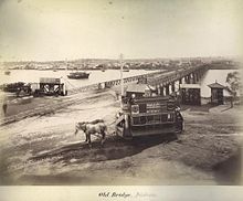
| 1865: | First was a temporary wooden bridge built between Brisbane and South Brisbane (that used tolls) while Victoria Bridge was being built.
Awkwardly in 1866, the Bank of Queensland which was financing the loan to the town council for the bridge, failed, and work stopped for a time. See section 5.2 on page 18 for more info on this bank. This wooden bridge, weakened by marine borers, then collapsed when a heavy load was crossing it at high tide and it closed in 1867.
|
| 1874: | Then, Victoria Bridge built (privately financed, with tolls to 1877).
|
| 1875: | Albert Bridge built as part of the Ipswich Railway Line between Indooroopilly (northside) and Chelmer. Rebuilt in 1895 after it was destroyed in 1893 floods.
|
| 1876: | Victoria Bridge taken over by Qld Govt in 1876.
|
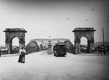
| 1885: | Leased by the government to private company who provided a horse-drawn tram service. Eighteen tramcars imported from America. In the words of the "Brisbane Courier" of the day they "are constructed of cedar and mahogany, highly polished, and are fitted with all the latest improvements. They are mounted on steel springs, making the motion almost imperceptible." Drawn by two horses, the single deck cars seat 16 passengers and the double deckers 40. Six and a half miles of double track constructed from Woolloongabba to Breakfast Creek with branches to the Exhibition Building and to New Farm.
Photo of Victoria Bridge 1890
with these Horse-Drawn Trams
Click here for a larger picture
|
| 1893: | Bridge demolished in 1893 floods. Temporary bridge rebuilt. Swept away again in 1896 after another deluge.
|
| 1897: | Second, more permanent Bridge built. Included in the rebuilding, an electric tram service.
Photo of Victoria Bridge (circa 1906)
Click here for a larger picture
|
| 1932: | William Jolly (Grey Street) Bridge built.
|
| 1936: | Walter Taylor (Indooroopilly) Bridge. Tolls until 1960s.
|
| 1940: | Story Bridge built linking Kangaroo Point southside with Fortitude Valley.
|
| 1955: | Indooroopilly Railway Bridge built between Indooroopilly and Chelmer, upstream of Albert Bridge, as a quadruplication of the Ipswich line 1955-1957.
|
| 1964: | Centenary Bridge built between Kenmore (northside) and Jindalee. One of its two lanes was closed for two years in 1974 after the bridge was damaged by a barge during the 1974 floods, with traffic lights necessary to co-ordinate single-lane traffic. In 1987 the bridge was duplicated, providing two lanes going north and two lanes going south.
|
| 1969: | Victoria Bridge rebuilt (yet again).
|
| 1972: | Captain Cook Bridge built as part of the Pacific Motorway (M3) linking Woolloongabba southside to Gardens Point.
|
| 1978: | Merivale Railway Bridge built slightly west of the Grey Street Bridge.
|
| 1986: | Gateway Bridge built (with tolls) linking Murarrie (southside) with Eagle Farm and the airport.
|
| 1998: | Jack Pesch Bridge built for pedestrians and cyclists linking Chelmer southside to Indooroopilly. Adjacent to Albert Bridge (for trains) and Walter Taylor Bridge (for cars).
|
| 2001: | Goodwill Bridge built for pedestrians and cyclists linking the South Bank southside to Gardens Point.
|
| 2006: | Eleanor Schonell Bridge (Green Bridge) built for buses, pedestrians and cyclists linking Dutton Park busway station southside to UQ Lakes busway station.
|
| 2009: | Kurilpa Bridge built for pedestrians and cyclists linking Kurilpa Park and Gallery of Modern Art on Montague Road southside to Tank Street. Click here for map.
|
| 2010: | Go Between Bridge built (with tolls) to honour Brisbane band the Go-Betweens, linking West End (southside) with Hale Street Milton and the Inner City Bypass.
|
| 2024: | Neville Bonner Bridge opened in August for pedestrians only (no cyclists) linking the South Bank southside to Queen's Wharf.
Kangaroo Point Bridge opened in December the same year for pedestrians and cyclists linking the Thornton Street ferry wharf in Kangaroo Point to the Alice Street-Edward Street intersection in the city.
|
|
|
|
|
Return to Table of Contents
First Ekka
http://www.rna.org.au/about-us/history-of-the-rna.aspx (archived)
The Royal National Agricultural and Industrial Association of Queensland (RNA) was established in 1875 with Governor Sir William Cairns as its President. Bowen Park was chosen in January 1876 as the site for the first Show. The 'Intercolonial Exhibition of 1876', held from August 22-26 proved a great success. A public holiday was declared and an estimated 15,000-17,000 people attended the opening day - a great feat at a time when the total population of Brisbane was just 20,600.
The RNA Showgrounds now become the centre of the city's social activities-musical and drama groups, football, cricket, lacrosse, athletics and cycling all had headquarters on grounds. In 1887, the Main Pavilion (corner of Bowen Bridge Road and Gregory Terrace) was destroyed by fire. In 1891, it was replaced with a new brick building, containing 1,300,000 bricks and completed in 23 weeks. 300 men were constantly at work during its construction. This building was equipped with a huge pipe organ by Wallis and Co of London, though it was later moved to the Brisbane City Hall after its completion in 1930.
Return to Table of Contents
Football in England, Australia (Melbourne in 1859 and Sydney in 1864) and USA
Brisbane Football Club
- In May 1866, Brisbane Football Club was the first known football club of any code in Brisbane. It played games in Queens Park i.e. the Botanic Gardens, following the "Victorian" Rules that had been codified in Melbourne in 1859. The club competed against four ad hoc teams in the Brisbane area between 1868 and 1869, including
- Volunteer Artillery
- the newly formed Brisbane Grammar School then located on land which is now the Roma Street railway station
- a Civil Service team
- and a police team
- In 1870 an Ipswich Football Club was formed.
- In 1875 Brisbane FC played "Association" rules against the inmates and warders of the Woogaroo Lunatic Asylum near Goodna
- In 1876 Petrie Terrace Football Club formed playing "Association" rules.
- Between 1876-1879 Brisbane FC played "Rugby Union" rules
- In 1880 Queensland Football Association formed playing both "Victorian" rules and "Rugby Union" rules
- In 1882 Brisbane FC match against Sydney (Rugby Union). With much antagonism from players who wished to adhere to "Victorian" rules, the club now split in two.
- In 1883 Queensland Rugby Union was formed as the Northern Rugby Union (NRU), a breakaway from the Queensland Football Association. Within two years, the NRU competition had six teams.
- In 1884 the Anglo-Queensland Football Association (AQFA) was formed to play Soccer fixture matches. The Brisbane Courier reported the first match of that first season, played on Saturday 7 June 1884. It took place on the Pineapple Ground, Kangaroo Point on Saturday, the contending clubs being the Queen's Park and St Andrew's. The clubs played eleven aside, being the usual number in matches under this association. The colours were for St Andrews dark blue and for Queen's Park blue and white. Mr Shiers was umpire for the Queen's Park, and Mr Curry filled the same position for the other side, Mr Hudson being referee. The attendance numbered about sixty, and most of them took a lively interest in the game.
- The defining moment in the football codes battle came with the 1886 Queensland [rugby] side, who defeated NSW for the first time in Sydney. "The success of this team undoubtedly won the day for rugby game in Queensland. The Victorian game supporters were struggling hard to uphold the premier position they had gained but after the brilliant performance of the 1886 team, who lost only one match through their tour, the rugby game became very popular and the next season several new clubs were formed and the Victorian game began to wane" (QRU Annual, 1902).
- By 1887 the NRU boasted 25 clubs. As the decade [1880s] came to a close, The Queensland Figaro summed up the state of play in the colony as "Rugby, an unbounded success; Melbourne rules very sick indeed, in fact on their last legs; British Association Rules [soccer], also in a sickly state but if anything showing more life than the Victorian game."
- The impact of Rugby League in Sydney and Brisbane in 1907-1908 was immediate. Its "Play the Ball" rule when tackled allowing spectators to see more of the ball, as well as professional match fees attracting top players meant many clubs switched codes. Following World War 1 the Queensland Rugby Union disbanded in 1919, reforming in 1928 when the GPS schools who had played rugby league since 1918, switched to union.
State of Origin and the Broncos
With rugby league interstate matches, each team drew its players from the clubs based in that state. With professional football clubs in Sydney "pinching" the best players in Queensland for their clubs, Queensland as a state was regularly thrashed by NSW. Before 1956, NSW won 75% and Qld 25% of series played. From 1956 to 1981, there was only one Qld win in 1959. But in 1980 the concept of State of Origin started, with Queensland winning the single match played 20-10. From 1982 it became a fixture, with Qld winning more frequently each year, followed by the Brisbane Broncos club providing weekly wins for many years.
With Wally Lewis (five-eighth) as the Broncos inaugural captain from 1988 to April 1990, then Allan Langer (half-back) as captain from 1992 to April 1999, the Broncos won the Rugby League Premiership four times, in 1992-1993 and in 1997-1998. Click here for links to Broncos matches played by these (and other players).
National Football Teams
Since 1980 Lang Park (Suncorp Stadium) has become Brisbane's home ground for State of Origin (rugby league), Brisbane Broncos (rugby league), Queensland Reds (rugby union), and **Brisbane Roar (soccer), national playing teams that represent three of Australia's four football codes with the exception of Aussie Rules (run by Victoria AFL).
For that the Brisbane Lions home ground is "the Gabba", built as the Brisbane Cricket Ground in 1896.
** For 3 seasons 2020-21, 2021-22 and 2022-23 Brisbane Roar moved to Moreton Stadium in Redcliffe, in 2023 known as Kayo Stadium/Dolphin Stadium, with the soccer team sharing the park with the Dolphins NRL club and coach Wayne Bennett (founding coach at the Broncos).
Local Football Teams
- Aussie Rules run by Queensland AFL (QAFL) since 1903.
- Federation Soccer run by Football Brisbane (within Football Queensland), latest incarnation of AQFA, first set up in 1884.
- Church Soccer run by Queensland Christian Soccer Association Inc since 1969.
- Queensland Premier Rugby (QPR) run by Queensland Rugby Union, latest incarnation of NRU, first set up in 1883.
- Brisbane Rugby League and Queensland Cup run by Queensland Rugby League, first set up in 1908.
Return to Table of Contents
First Electric Lighting (and Gas Lighting) and Power
http://www.itee.uq.edu.au /pes/early-electricity-usage-brisbane
https://en.wikipedia.org/wiki /History of electricity supply in Queensland
Prior to 1882 in Australia, the telegraph and even the new telephone were in use, powered by an electric battery. A battery could also be used to power a carbon arc lamp, but these were a difficult sell to customers because the batteries were not reliable, very expensive, and had a short life.
Gas street lamps (a by-product of burning coal) were first introduced to Brisbane in November 1865 using gas towers at Petrie Bight. Due to arrears of payment it was switched off shortly after until 1870, when the new colony's financial situation had recovered sufficiently. By 1880, 250 gas street lamps in the CBD were being lit every night.
Then, early in 1882, electric lighting (using a DC steam-engine powered dynamo) was installed in Sutton's Foundry on the corner of Adelaide Street and Foundry Lane (later renamed as Isles Lane — Post Office Square).
In December that year a large crowd gathered near Victoria Bridge to witness the first demonstration of public street lighting. Eight arc lamps were positioned between Eagle Street and Victoria Bridge. The lights were powered by a 10 hp (7½ kW) dynamo situated in Sutton's Foundry. Several Queen Street shop windows were also lit by electric light as part of their Christmas decorations. Note, the only cities in the world that had similar installations in that year were New York and London. In 1883, lighting was installed at the Govt Printing Office, and in 1884 at The Brisbane Courier.
In 1886, the laying of underground cable between Parliament House and the Govt Printing Office was complete, with Toorak-born Mr E.C. Barton, as Queensland Government's electrical engineer, supervising the laying of the cable. Prior to his return to the Southern Hemisphere this man had apparently superintended the first commercial electric-lighting system in Britain at Godalming Surrey in 1882. Now, in 1888, forming a company with Mr C.F. White, he built a power house in Edison Lane behind the Post Office with a 30 kW generating capacity. Barton and White then became the first electricity supply company in Australia, with the Brisbane Post Office their first customer. Adjoining shops were supplied by overhead wires, the first non-government customers. Unfortunately his firm shortly went bankrupt. Succeeded in 1894 by his Brisbane Electric Supply Co Ltd, then in 1904 by City Electric Light Co Ltd (CEL).
In 1897, Brisbane Tramway built Queensland's first significant power station at Countess Street in Brisbane, initially at 900 kW, boosting it to 4.05MW by 1915. Some places in Red Hill and Ithaca also receive supply from this private company. Click here to read more about the Tramways below.
In 1914 CEL converted from DC to AC, extending supply outside centre of Brisbane. Gas lighting was replaced with electric street lighting from 1917 onwards. Over time, as new buildings were erected in the CBD, the remaining gas lampposts were removed. The gas lampposts in William and George Streets are possibly the only examples of this early form of street lighting remaining in Brisbane.
After World War One, electricity supplies proliferated statewide and nationwide.
In 1928, the New Farm Powerhouse was built by the Brisbane City Council, who had acquired the Brisbane Tramway. The Countess Street power station was decommissioned. The New Farm Powerhouse, in addition to supplying Brisbane Tramway, now allowed for the construction of an 11 kV network to supply power for electric light to greater Brisbane. Previously CEL had supplied power to residences under 10 year orders, but with Council having this new powerhouse, they slowly inherited these new areas of supply as each order expired. By 1935, only the old City of Brisbane and City of South Brisbane were being supplied by CEL, with the rest of greater Brisbane, as well as the Tram Lines, supplied by the BCC Electricity Supply Department.
In 1938, the State Electricity Commission Qld (SECQ) was established to coordinate electricity distribution state wide. It quickly strengthened CEL by actively ensuring that all the other electricity undertakings in South East Queensland were absorbed into the one entity. By 1940, CEL had acquired the generating and distribution assets at Ipswich, Southport, Nambour, Coolangatta, Gympie, Redcliffe, Boonah, Beaudesert and Highfields, and the Tweed Shire in northern New South Wales. This created a situation where the two electricity providers in South East Queensland were the BCC and CEL. These two systems were connected in 1940 as a wartime contingency. In 1945, seven state boards were established: 1.SEQEB, 2.SWQEB, 3.Wide Bay-Burnett, 4.Capricornia, 5.Mackay, 6.North Queensland (NQEB), and 7.Far North Queensland Electricity Board.
In 1953, the SECQ formed the Southern Electricity Authority (SEA) which then acquired CEL. It also acquired the Tennyson Power Station, under construction by the Brisbane City Council. The New Farm Powerhouse remained under the ownership of the Brisbane City Council until it was sold in 1963 to the SEA. It was then decommissioned in 1971, with BCC's closing of Brisbane's Tram Lines.
1977 SEQEB becomes electricity supplier for all of South East Queensland (including Brisbane). Now the state board, not the city council, is in charge of meter reading and supply.
1997 saw the formation of the National Electricity Market and a number of
Qld Government Owned Corporations (GOCs) — as SEQEB became Energex.
- CS Energy and Stanwell Corporation to oversee all generator sites in Queensland
- Powerlink Queensland to oversee all high-voltage transmission infrastructure
- Energex and Ergon Energy to oversee all end-user emergency issues (including fallen powerlines) reporting
Retailing of electricity supply Australia-wide is now managed by private corporations, the two largest retailers becoming Sydney-based companies Origin Energy (previously known as Boral) and AGL Energy.
Return to Table of Contents
Electric Tram Lines
http://www.brisbanetramway museum.org /documents/morwoodtrams.pdf
http://espace.library.uq.edu.au /eserv/UQ:207895/s18378366 1944 3 3 209.pdf
https://en.wikipedia.org/wiki/Trams in Brisbane
https://en.wikipedia.org/wiki/
Brisbane Transport
https://en.wikipedia.org/wiki/1912 Brisbane general strike
| 1895 | On 30 September, a company newly formed in London, called the Brisbane Tramways Company Limited, purchased Brisbane's horse car tramway system for £105,200 with the intention of converting it to electric operation and extending it. The electrical equipment for the tramcars was ordered from the General Electric Company of America who sent Mr J. S. Badger to install it. He remained in Brisbane for 27 years, most of the time as General Manager and Managing Director of the Company.
|
| 1897 | The first electric tram runs along Stanley Street South Brisbane on June 21 with service to Queen Street coming 12 days later. All in all there were 20 tramcars running on 15 miles of track, electricity being supplied from a power station in Countess Street. Over the next 25 years tram lines extended to Toowong and Kedron north of the river, Dutton Park and Greenslopes south of the river, with Mr Badger inaugurating band concerts and picture show outings on summer evenings.
|
| 1912 | General Strike called in Brisbane on 30th January after Mr Badger had refused tram workers the right to wear their union badges to work and dismissed the workers who refused to comply. Escalated rapidly with 25,000 workers marching through Brisbane on 31st January in protest. Within a few days the Strike Committee became an alternative government, with State Government departments and private employers needing the Strike Committee's permission to carry out any work. Lasted five weeks. The conservative Denham State Government immediately won an ensuing election on a "Law and Order" platform and passed the Industrial Peace Act of 1912 that ushered in compulsory arbitration specifically to deter strikes in essential services. Employees of the tramway company who struck were sacked with the tramway company refusing to ever re-hire the workers. Yes, a standoff with everyone pretty cranky.
|
| 1922 | Qld State Government oversees purchasing of the company with its infrastructure for just over £1,000,000, and then reinstates these sacked workers.
|
| 1925 | As mentioned, the Qld Government formed the Brisbane City Council this year, to run the company, amalgamating the two cities Brisbane and South Brisbane, six towns — Toowong Ithaca (i.e.Paddington and Red Hill) Windsor Hamilton Sandgate and Wynnum, ten shires — Moggill Taringa Enoggera Kedron Toombul north of the river, Balmoral Belmont Coorparoo Sherwood Stephens (Annerley) south of the river, and a city part of the shires of Yeerongpilly and Tingalpa.
Citywide Tram services greatly expanded. Interestingly, badges on tram and then bus uniforms — the cause of the strike — were forbidden and were to remain forbidden until 1980.
|
| 1926 | Extended to Holland Park.
|
| 1951 | To Mt Gravatt.
|
| 1969 | Closed.
|
Return to Table of Contents
Govt Primary Schools - Brisbane Normal School
http://education.qld.gov.au/library
/docs/edhistory/stateedu.pdf (archived)
It was NSW Governor Fitzroy who set up the National Education Board in Sydney in 1848. Apparently a lot of what he did was based on the multi-denominational National Schools in Ireland (set up in 1831), and he brought out a large number of Irish readers (there not being any Australian reading books printed at the time) .
Click here, re our first Queensland readers.
In 1850, a primary school following this NSW system opened in Warwick East and a second school in 1851 in Drayton Toowoomba.
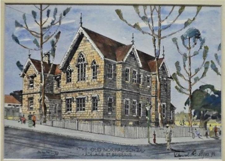 In early 1860, the National Board, later that year to become the Qld Board of General Education opened the Brisbane National School in Adelaide Street in a new building close to what is now Anzac Square. In 1920 it became Brisbane Junior State High School photo on right courtesy BSHAlumni News - Amicus April 2025
Its first Headmaster in 1860 was John Rendall and on its opening day the attendance was 50 boys and 8 girls. It was conducted as a mixed school until 14 August 1860 when the girl pupils were (temporarily) moved to an old wooden chapel at the corner of Ann and Creek Streets, forming the Brisbane Central Girls' School for girls and infants under its Headmistress Margaret Berry. In December 1862 the school moved back to that building in Adelaide Street, with the Boys School — now also known as Brisbane Normal School with a training school for teachers — moving next door to their new building on the corner of Adelaide and Edward Streets.
Normal schools — derived from the French "Ecole Normale" provided a model curriculum that the government expected of all its public schools, with teachers trained accordingly to follow the model, the "norm" when providing education.
Within five years many public (and a few church) primary schools had opened in Brisbane and Ipswich. Schools also opened in Dalby and Gladstone in 1861, Rockhampton Central Boys (now closed), Maryborough and Leyburn (SW of Toowoomba) in 1862, Gayndah and Condamine in 1863, Laidley South (now closed) and Goondiwindi in 1864, Toowoomba South and Bowen in 1865.
Boys Grammar schools opened that majored on the classical subjects such as Latin, and which also provided accommodation for boarders, starting with Ipswich Grammar in 1863, Brisbane Grammar in 1868, and Toowoomba Grammar in 1877.
Girls Grammar schools opened, which also provided accommodation for boarders, somewhat of a novelty at the time, starting with Brisbane Girls Grammar in 1875. One of its headmistresses formed the private Brisbane High School for Girls in 1899 — later to be known as Somerville House after 1918 under a newly formed Presbyterian and Methodist Schools Association (PMSA).
Back to Brisbane Normal School. In 1870, fees to the school were abolished. While there seems to have been little regularity in the amount (or collection) of these fees, their collection (as high as one shilling per week per child) seems to have also encouraged irregularity of attendance.
In 1875, the same year as England, primary education for children was made compulsory from ages 6 to 12. The year in which you turned 6 then generally became Grade 1, and the year you turned 13 generally became Grade 8, though children could be one year older. Note too, this compulsory provision was not fully implemented until 1900. In 1912 the minimum school leaving age became 14 years.
First Govt Technical College and High School
Intro
If you were academically bright, you might win a scholarship to further your secondary education, but until the 1950s and 1960s building "free" high schools in Brisbane just wasn't a priority for the State Government. Free state schools generally included teaching up to Grade 8, but that was it. A handful of country seats got looked after, having proper free high schools, but in Brisbane there was only the Tech College/Brisbane State High School, with Wynnum State High not being built until 1942.
Brisbane Technical College 1882
The early beginnings to the Tech College started in 1849 with the Brisbane School of Arts, built on the corner of Queen and Creek Streets. Formed as a Mechanics' Institute local community group, similar to many others in Britain and Australia, it provided a library for members, conducted public lectures, and organised classes in a wide variety of subjects. In May 1878 it shifted to a redeveloped building (having verandahs) on Ann Street.
The institute we now refer to as the Brisbane Technical College was founded when the Brisbane School of Arts gained Queensland Government funding to establish a technical college, with a hall added to the rear of the building in 1884. Enrolments were initially 80 students but soon rose to be over 1000 students in 1897. A Mechanics Institute and Library opened in South Brisbane in 1889, along with a School of Arts in West End, with South Brisbane's funded as a Technical College in 1897 and West End in 1899.
Central Technical College 1908
The Queensland Government merged South Brisbane, West End, Brisbane Technical Colleges to form the Central Technical College, with new buildings at lower George Street near the Botanical Gardens (today's QUT).
University of Queensland 1911
Lower George Street also became the site for the University of Queensland, initially created by an act of the State Government in 1909. In 1910 the first University teaching faculties were ready. These included engineering, classics, mathematics and chemistry. In 1911 the first students were enrolled, using the Old Government House for the lectures, with the Governor of Queensland shifting his residence and offices across to Fernberg in Bardon. The Old Government House continued to be used by the university for various means until the late 1960s.
1913 Back to the Tech College (now also a High School). New high school classes were commenced in 1913 when headmasters in various metropolitan state schools were asked to nominate 76 boys and girls for free admission to the College, along with a further 70 paying students who thus made up its first year's enrolment.
Marianne Bryden, an educationist with many years experience, became supervisor for three years. There was insufficient room in 1913 in the George Street buildings, so classrooms were provided at the School of Arts in Ann Street for one year, then the expanding College moved into the buildings (finally finished).
1914 Also started in 1914 in those buildings was the Queensland Teachers' Training College, the fore-runner of Kelvin Grove Teachers College.
Greater Public Schools (GPS) Association 1918
The Central Technical College formed the association together with the three Grammar schools Brisbane, Ipswich, Toowoomba and with five Church schools Gregory Terrace (Catholic), Nudgee College (Catholic), Southport School (Anglican), "Churchie" Grammar (Anglican) and BBC (PMSA). It provided an environment for "healthy competition" in their sporting and cultural activities.
A similar association for girls was the Queensland Girls' Secondary Schools Sports Association.
Brisbane Junior State High School 1920
In January 1920, the Brisbane Central Secondary School was established at the Brisbane Normal School with Isaac Waddle as headmaster, combining the secondary departments of the Boys School and the Girls school while establishing a state curriculum model. The scope of its instruction that year was limited to studies necessary for the Junior Public Examination. During the year, the name was changed to Brisbane Junior State High School. In 1921 it took over responsibility for all the High School classes at the Central Technical College, also amalgamating the High School Department at Wynnum State School. On 1st July 1921 it reconstituted as Brisbane State High School or BSHS, having its curriculum extended to include Senior Public Examination and Matriculation subjects.
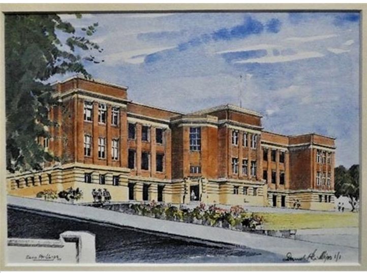 Brisbane State High School 1925
Its site on the corner of Vulture and Ernest Streets, South Brisbane had been reserved for educational purpose back in 1917.
The Foundation Stone for the Red Brick Building was laid on 22nd September 1923 and the school opened on 27th January in 1925, see photo on right. In 1930 Brisbane State High School replaced Central Technical College's name inside the GPS Association.
In 1927 the Brisbane Normal School (Adelaide Street) closed for demolition. All of its primary teachers and students were now at Leichhardt Street State School, built back in 1875. The Leichhardt Street school also took over the Normal School's role of training teachers, becoming unofficially known as the Central Practising School. In 1954, the school was officially renamed as Brisbane Central State School.
University of Queensland's move to St Lucia: Also in 1927, Dr James Mayne and Miss Mary Emelia Mayne provided a grant of approximately £50,000 to the Brisbane City Council to acquire 274 acres (111 ha) of land in St Lucia and provided it to the University of Queensland as its permanent home.
Click here to read about this family.
However, construction was delayed while enrolments steadily increased at both the campus on George Street, and the Brisbane Central Technical College. In 1935 in George Street a building was constructed to commemorate the 25th anniversary of the University's foundation, and was shared by both institutions. It accommodated the Library of the University, and various facilities for the Technical College — classes for architecture and building construction, and from 1938 part of its Commercial High School 1926-1963.
Construction at St Lucia finally began in 1937. But before the first building (the Forgan Smith Building) could be occupied in 1939, the needs of World War 2 intervened, and the St Lucia campus served as Advanced Headquarters for the Allied Land Forces in the South West Pacific. When the war ended, the university's doors at St Lucia finally opened in 1949, with new Residential Colleges built on the St Lucia campus in the 1950s and 1960s. The University's move from George Street was finally completed in 1972.
QIT 1965 and QUT 1987
In 1965 Central Tech College became Queensland Institute of Technology, then in 1987 Queensland University of Technology.
Its annexe on Ernest Street South Brisbane since 1945 now became South Brisbane Institute of Technology, then in 2014 South Bank TAFE (Technical and Further Education) - TAFE a Qld Govt term from 1973.
TAFE Mt Gravatt Campus which had opened on Cavendish Road as Moreton TAFE ca.1995, become Metro South TAFE in 2006, completed an upgrade in 2022 as TAFE Qld Headquarters, transferring from 133 Mary Street in the CBD.
Other University Developments
In 1969 Mt Gravatt Teachers College opened, becoming a College of Advanced Education in 1982.
In 1975 Griffith University opened its campus at Nathan, with 451 students.
In 1990 Mt Gravatt Teachers College merged to become its Mt Gravatt campus, Kelvin Grove College merged with QUT.
School Leaving Age recent changes
Since 1950 with a steadily growing local population, many more free High Schools have been built in Brisbane's suburbs and in Queensland country cities and towns. In 1964 the minimum leaving age in Queensland became 15 years. That same year Queensland primary schools lost their Grade 8 year, it became part of regular high school.
In 2006 the leaving age became 16 years, or to have completed Grade 10. In 2009 it became 17 years or to have completed Grade 12, though 16 years is still acceptable if you have a minimum 25 hours employment / education weekly. In 2015, Queensland primary schools lost their Grade 7 year, it is now part of regular high school.
Click here for a fully merged list of all current Queensland Schools as at 7 Jan 2023 sortable by name and by date opened.
Click here for the Wikipedia lists on which it is based, having numerous subdivisions by geographical area.
Return to Table of Contents
Public Holidays in Queensland
From 1788 Christmas Day, Boxing Day, New Year's Day, Good Friday and Easter Monday have been traditional holidays. Also, of course, Sundays. And from 1788, 4th June, i.e. the King (or Queen's) Birthday, after 1936 always second Monday in June, after 2016 in Queensland first Monday in October
Australia Day (26 January) was officially made a public holiday in 1818 by Governor Macquarie
Exhibition Wednesday in August since 1876 to coincide with the Royal Queensland Show (Ekka) in Brisbane, noting other local government areas have their show holidays on different days
Labour Day (first Monday in May) following demonstrations from 1850s, became a public holiday in 1901 (as Eight Hours Day), and Labour Day in 1912
Anzac Day (25 April) ever since 1916, in honour of the men who fought (and died) at Gallipoli in 1915
National Retailers
Extract below from "The Way we Were" with Jayne Keogh in conversation with John Berry in Sunday Mail 1st Oct 2023.
Click here for the full article.
The first free settlers to Brisbane were fed by the sympathy of the Government Commissariat Store on the Wharf in George Street that had been set up in 1829. As the town grew, entrepreneurial types set up general stores selling basic dry goods, people grew vegetables, kept chickens and cows.
The wealthier had their food basics delivered by boys in a horse and cart to the "tradesmen's entrance" for the cook from individual traders. By the 20th Century these shops had expanded from town centres to surrounding suburbs, but the shopping list still needed delivery to most households.
Due to lack of refrigeration, meat and dairy had to be purchased daily due to our hot summers and few people owned cars. This system of delivery continued in the new suburbs, built to accommodate returning veterans (from WW1), using their War Service Loans. The local baker would arrive with large open baskets filled with flour-dusted loaves, finger buns and soft dinner rolls, fresh vegetables and fruit from an open-sided truck, the "milko" with milk and cream and newspapers hurled twice a day by a man driving a car - with the driver's door missing!
However, shopping rapidly changed to supermarkets, pioneered in Brisbane, the first in Australia. The self-service grocery store Piggly Wiggly was invented in Memphis, Tennessee in 1916. Canny Scottish immigrant Claude Fraser heard about this and in 1921 opened Brisbane Cash and Carry (BCC) in Fortitude Valley. His second store opened next in 1922 in West End.
The concept was simple: rows of stacked open shelves where the shopper helped themselves, popped the items into their own basket, unloaded on to a counter for the shop assistant to tally up in her head, and paid for in cash.
In 1927 Woolworths arrived, having opened its first Sydney store in 1924. In 1958, it purchased Brisbane Cash and Carry (BCC), 32 grocery stores that formed the basis of its entry into the grocery market in Queensland. In the 1970s the company opened discount department stores under the brand Big W, converting the last centre into either a supermarket, or a Big W in 1989. It became a public traded company in 1993. Click here to see some early photos.
Woolworths was followed in Brisbane in 1932 by its close rival, Coles, which had opened in Melbourne in 1914. In 1969 it started K-Mart, working with the US until 1978, when it acquired full ownership of the operation. From 1985 - 2006 it merged with Myer (and Target) and formed Officeworks in 1994. In 2007 Coles was purchased by Wesfarmers until 2018, when Coles was spun-off as a separate public company. Click here for a biography of Arthur William Coles 1892-1982.
Two other national rivals arrived in 1955
- David Jones, who had opened in Sydney way back in 1838. Their arrival in Brisbane came with their taking over Finney Isles in Queen Street Brisbane, and then T C Beirnes in Fortitude Valley the following year. Neither department store changed its trading name, initially. In 2014 David Jones was purchased by Woolworths South Africa, in 2022 by Sydney firm Anchorage Capital.
- Myer, who had first opened in Melbourne in 1911. Their arrival in Brisbane came with their taking over McWhirters in Fortitude Valley in 1955 (leaving its name temporarily), next Allan and Stark in Chermside in 1959, and Queen Street in 1970. It crossed Queen Street road in 1988, then closed there in July 2023.
Myer opened in Indooroopilly Shoppingtown in 1970, Carindale in 1984, Garden City Upper Mt Gravatt in 2014.
In the early 1970s Myer opened its Target stores. It merged with Coles in 1985, separated in 2006, became a publicly traded company in 2009.
Return to Table of Contents
Olympics Stadiums announcement in Courier Mail 25 March 2025
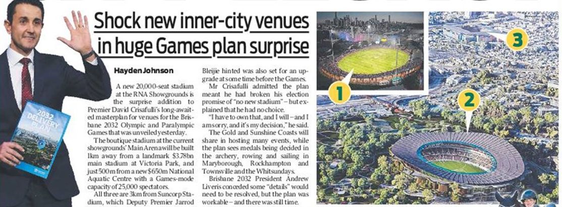
Click here for the full article
Return to Table of Contents
Pools Swimming
City Council currently 22 pools
State Library Qld
1857: Public Baths Brisbane River (one shilling a bathe, 20 shillings for 3 months)
1886: Spring Hill Baths
1924: Davies Park Mixed Baths
The Valley Pool (in 1903) became the home of the powerhouse Commercial Swimming Club that spawned Kieren Perkins, Libby Trickett, Susie O'Neill, Hayley Lewis, Samantha Riley and many other Olympians.
Click here for an interview in 2015 with two of its recent members Bronte and Cate Campbell — world record holders at the time in the 100m freestyle, and the 50m freestyle.
Return to Table of Contents
Population Growth Brisbane and its surrounding Metropolitan area
1859: 6,000
Brisbane's first Town Hall on Queen Street, with its foundation stone laid in 1864, was completed in 1867.
1881: 37,000
1891: 100,000
With huge growth during past decade, in 1888 South Brisbane became a separate municipality. In 1892 its Town Hall was completed. By this year though, the municipality was being referred to in the Brisbane Courier newspaper not as a town but as a "city". In 1903, the Queensland State Government officially named the separate Brisbane municipality as a "city".
1921: 200,000
In 1925, the Queensland State Government amalgamated these two separate cities, plus surrounding towns and shires, into the greater City of Brisbane. Brisbane's City Hall on King George Square, started in 1920, was then opened in 1930.
1933: 300,000
1947: 400,000
1954: 500,000
1961: 620,000
1971: 870,000
1981: 1 million
In 1982, the Queen Street Mall was built for the Commonwealth Games in Brisbane. Road traffic through Queen Street became no longer possible as Queen Street was closed between Albert and Edward Streets. In 1988 and World Expo, the Queen Street Mall was extended from Albert Street to George Street, plus an entrance and exit at Victoria Bridge to the Queen Street Bus Station at the time the largest underground diesel bus station in the world.
1994: 1½ million
2008: 2 million
In 2008 the Queen Street Mall was extended again along Albert Street between Queen Street and Adelaide Street.
2020: 2½ million with Queensland at 5 million (estimate).
Since 1971, Greater Brisbane has steadily stretched to a distance of 200 kms that now includes Brisbane north to Caboolture and Kilcoy, west to Laidley and Esk, south to Boonah, Beaudesert and Beenleigh, but excluding the Sunshine Coast and the Gold Coast.
Local Govt Areas are: Brisbane City (from Eight Mile Plains in the south to Aspley in the north) 1.23 million, Moreton Bay Region (Strathpine, Redcliffe and Caboolture in the north) 460 thousand, Redlands in the east 160 thousand, Logan in the south 320 thousand, Ipswich in the west 210 thousand, Somerset (Esk) in the west north-west 25 thousand, Lockyer Valley (Gatton, Laidley) in the west south-west 40 thousand, and Scenic Rim (Beaudesert) in the south-west 40 thousand.
Todays City Streets and one-way directions
Kenneth James Morris KBE CMG
www.expressway.net.au
The first traffic lights were installed at the junction of Ann Street, Albert Street and Roma Street on 21 January 1936.
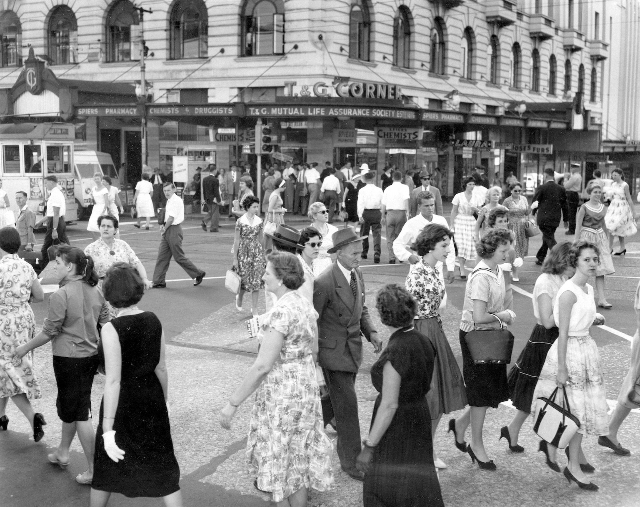 The development of one-way streets began under Deputy Premier and Minister for Labour and Industry (and Police) Kenneth James Morris, in 1959. To cope with the increasing use of cars in Brisbane's inner city, see Facebook image on right, Sir Kenneth implemented a traffic plan of coordinated traffic lights and one-way streets.
Subsequently in 1965, traffic management became the responsibility of the Brisbane City Council.
At 6am on Tuesday 6th April 1974, Ann Street famously, and quietly, reversed its one-way direction. It was the year of the 1974 floods when all of Brisbane City streets (below Ann Street) became inaccessible to traffic coming out of Fortitude Valley. The opening up of Ann Street so traffic could flow south, while controversial (and chaotic) at the time, it solved that problem, somewhat.
List of streets below.
Countess Street (far west) one-way (towards south)
Ann, Charlotte and Alice Streets all one-way (towards south-west)
Tank Street, Turbot Street that becomes Wickham Street in Fortitude Valley, Elizabeth Street and Margaret Street all one-way (towards north-east) noting that Margaret becomes Felix Street before it becomes Mary Street.
North Quay-Queen's Wharf, Edward, Market Streets and Clark Lane one-way (towards south-east).
George, Albert and Creek Streets one-way (towards north-west) with George and Albert streets currently two-way between Charlotte and Alice Streets.
Two-way William Street closed Jan 2017 to Aug 2024 for the resort's development culminating in the opening of the Neville Bonner Bridge in August 2024. In recent news, Star Entertainment who manage this development had their 50% ownership stake bought out by their China partners in March 2025 then received a further bail-out loan from Bally's in the US, in April.
Click here for a Google Map to the City
Further Background
http://queenslandplaces.com.au
/brisbane-and-greater-brisbane
Go Top
** End of Report
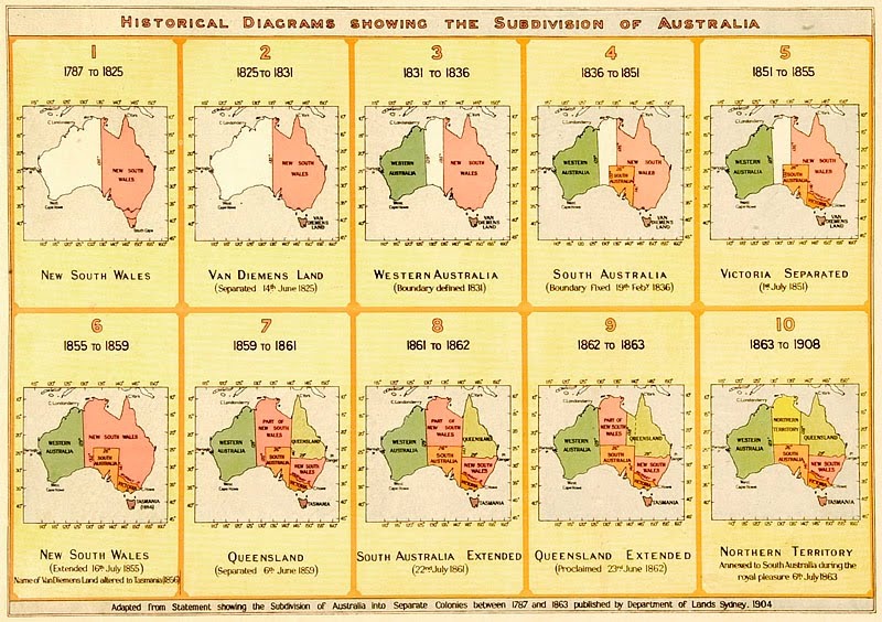
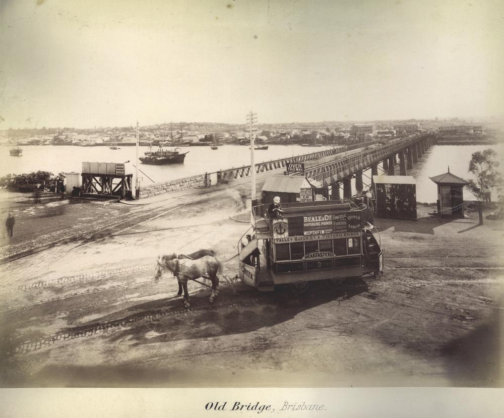